Guayanilla night lights from space
Night Light of Guayanilla from space (Puerto Rico) Src. Average luminocity for 10x10km area is 39.4004% and for 50x50km: 14.959%.
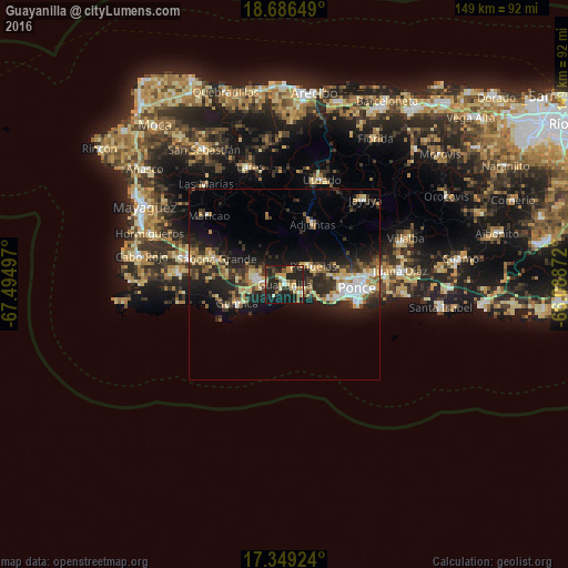
Analysis of Guayanilla night lights 2016
Square area 10x10 km:
 2.6%
2.6%90-99
3.03%80-89
6.93%70-79
8.87%60-69
5.41%50-59
5.63%40-49
1.95%30-39
8.23%20-29
32.03%10-19
24.89%0-9
0.43%Square area 50x50 km:
1.47%90-99
1.71%80-89
2.57%70-79
1.93%60-69
2.05%50-59
1.66%40-49
1.62%30-39
3.94%20-29
6.19%10-19
10.34%0-9
66.51%Clear (daylight) street map image can be seen on geolist.org.
Map coordinates:
18° 41' 11.4" North, 67° 29' 41.9" West
18° 1' 8.9" North, 66° 47' 30.6" West
17° 20' 57.3" North, 66° 5' 19.4" West
Some cities around Guayanilla sort by population:
• Ponce
17.8 km =11.1 mi,  93°
93°
• Yauco
6.4 km =4 mi,  285°
285°
• San Germán
27.6 km =17.1 mi,  284°
284°
• Guánica
13.4 km =8.3 mi,  246°
246°
• Sabana Grande
19 km =11.8 mi, 290°
• Peñuelas
8.5 km =5.3 mi,  60°
60°
• Adjuntas
17.6 km =10.9 mi,  24°
24°
• Maricao
26.8 km =16.7 mi,  312°
312°
4565111 (p: 5,213)
Sources (retrieved 2019-11-25):
» Earth at Night: Flat Maps 2012, 2016