Arroyo night lights from space
Night Light of Arroyo from space (Puerto Rico) Src. Average luminocity for 10x10km area is 33.961% and for 50x50km: 16.2922%.
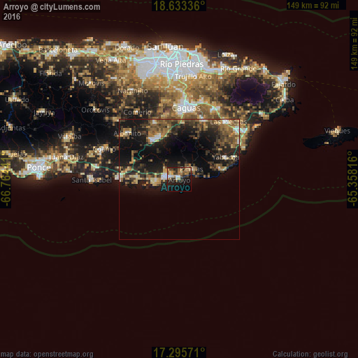
Analysis of Arroyo night lights 2016
Square area 10x10 km:
100  1.95%
1.95%
90-99 3.03%
80-89 6.06%
70-79 5.41%
60-69 5.84%
50-59 7.58%
40-49 5.41%
30-39 5.19%
20-29 13.42%
10-19 25.32%
0-9 20.78%
1.95%90-99
3.03%80-89
6.06%70-79
5.41%60-69
5.84%50-59
7.58%40-49
5.41%30-39
5.19%20-29
13.42%10-19
25.32%0-9
20.78%Square area 50x50 km:
100 0.97%
90-99 1.2%
80-89 2.18%
70-79 1.71%
60-69 2.91%
50-59 3.07%
40-49 3.75%
30-39 4.58%
20-29 5.62%
10-19 14%
0-9 59.99%
0.97%90-99
1.2%80-89
2.18%70-79
1.71%60-69
2.91%50-59
3.07%40-49
3.75%30-39
4.58%20-29
5.62%10-19
14%0-9
59.99%Clear (daylight) street map image can be seen on geolist.org.
Map coordinates:
18° 38' 0.1" North, 66° 45' 51.9" West
17° 57' 56.9" North, 66° 3' 40.6" West
17° 17' 44.6" North, 65° 21' 29.4" West
Some cities around Arroyo sort by population:
• Guayama
5.9 km =3.7 mi,  290°
290°
• Cayey
19.7 km =12.2 mi,  325°
325°
• Yabucoa
21.4 km =13.3 mi,  63°
63°
• Salinas
25.1 km =15.6 mi,  272°
272°
• Coco
21.4 km =13.3 mi,  282°
282°
• Cidra
25.6 km =15.9 mi,  335°
335°
• Patillas
6.6 km =4.1 mi,  46°
46°
• Maunabo
17.7 km =11 mi,  74°
74°
4562681 (p: 7,520)
Sources (retrieved 2019-11-25):
» Earth at Night: Flat Maps 2012, 2016