Wąbrzeźno night lights from space
Night Light of Wąbrzeźno (Kujawsko-Pomorskie) from space (Poland) Src. Average luminocity for 10x10km area is 8.9129% and for 50x50km: 3.6612%.
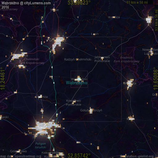
Analysis of Wąbrzeźno night lights 2016
Square area 10x10 km:
 1.01%
1.01%90-99
2.27%80-89
1.77%70-79
0.88%60-69
0.51%50-59
1.14%40-49
0.51%30-39
0%20-29
0.51%10-19
0%0-9
91.41%Square area 50x50 km:
0.72%90-99
0.7%80-89
0.3%70-79
0.32%60-69
0.41%50-59
0.3%40-49
0.18%30-39
0.3%20-29
1.28%10-19
2.66%0-9
92.83%Clear (daylight) street map image can be seen on geolist.org.
Map coordinates:
53° 41' 53.6" North, 18° 14' 40.6" East
53° 16' 47.6" North, 18° 56' 51.8" East
52° 51' 26.7" North, 19° 39' 3.1" East
Some cities around Wąbrzeźno sort by population:
• Toruń
37.7 km =23.4 mi,  218°
218°
• Grudziądz
26.1 km =16.2 mi,  330°
330°
• Brodnica
29.9 km =18.6 mi,  94°
94°
• Świecie
36.2 km =22.5 mi,  293°
293°
• Chełmno
35.5 km =22.1 mi,  282°
282°
• Rypin
38.9 km =24.2 mi,  127°
127°
• Chełmża
25.2 km =15.7 mi,  245°
245°
• Golub-Dobrzyń
20.1 km =12.5 mi,  159°
159°
3082734 (p: 13,911)
Sources (retrieved 2019-11-25):
» Earth at Night: Flat Maps 2012, 2016