Trzebnica night lights from space
Night Light of Trzebnica (Lower Silesia) from space (Poland) Src. Average luminocity for 10x10km area is 4.8389% and for 50x50km: 10.5371%.
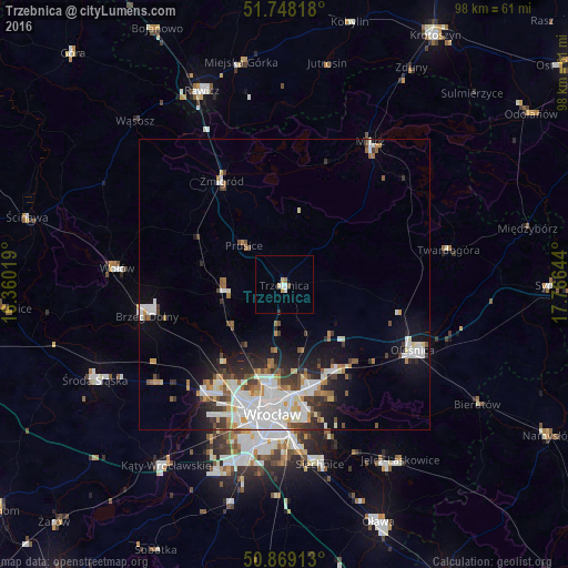
Analysis of Trzebnica night lights 2016
Square area 10x10 km:
 1.26%
1.26%90-99
0.42%80-89
0.84%70-79
0.84%60-69
0.42%50-59
0.14%40-49
0.56%30-39
0.28%20-29
0%10-19
0%0-9
95.24%Square area 50x50 km:
2.85%90-99
2.52%80-89
0.73%70-79
0.87%60-69
1.07%50-59
0.84%40-49
1.16%30-39
1.3%20-29
2.1%10-19
4.44%0-9
82.11%Clear (daylight) street map image can be seen on geolist.org.
Map coordinates:
51° 44' 53.4" North, 16° 21' 36.7" East
51° 18' 38.7" North, 17° 3' 47.9" East
50° 52' 8.9" North, 17° 45' 59.2" East
Some cities around Trzebnica sort by population:
• Kozanów
19.6 km =12.2 mi,  199°
199°
• Różanka-Polanka
18.8 km =11.7 mi,  189°
189°
• Karłowice
18.9 km =11.7 mi,  182°
182°
• Zgorzelisko
19.8 km =12.3 mi,  165°
165°
• Zakrzów
16.9 km =10.5 mi,  162°
162°
• Oborniki Śląskie
10.4 km =6.5 mi,  264°
264°
• Maślice Małe
19.8 km =12.3 mi,  205°
205°
• Psie Pole Południe-Kiełczów
18.7 km =11.6 mi, 166°
3083103 (p: 12,212)
Sources (retrieved 2019-11-25):
» Earth at Night: Flat Maps 2012, 2016