Szamotuły night lights from space
Night Light of Szamotuły (Greater Poland) from space (Poland) Src. Average luminocity for 10x10km area is 13.8228% and for 50x50km: 8.5608%.
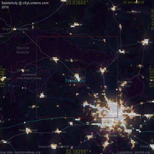
Analysis of Szamotuły night lights 2016
Square area 10x10 km:
 3.44%
3.44%90-99
2.38%80-89
1.19%70-79
1.46%60-69
1.32%50-59
1.32%40-49
0.26%30-39
0.4%20-29
1.19%10-19
6.48%0-9
80.56%Square area 50x50 km:
2.39%90-99
1.85%80-89
0.75%70-79
0.64%60-69
0.7%50-59
1.07%40-49
0.59%30-39
1.06%20-29
1.65%10-19
3.42%0-9
85.88%Clear (daylight) street map image can be seen on geolist.org.
Map coordinates:
53° 2' 12.8" North, 15° 52' 29.4" East
52° 36' 43.2" North, 16° 34' 40.6" East
52° 10' 58.7" North, 17° 16' 51.9" East
Some cities around Szamotuły sort by population:
• Oborniki
16.4 km =10.2 mi,  76°
76°
• Wronki
17.2 km =10.7 mi,  309°
309°
• Rogoźno
31.9 km =19.8 mi,  60°
60°
• Murowana Goślina
29.4 km =18.3 mi,  98°
98°
• Pniewy
24.5 km =15.2 mi,  242°
242°
• Buk
28.8 km =17.9 mi,  187°
187°
• Plewiska
31.4 km =19.5 mi,  150°
150°
• Czerwonak
31.8 km =19.8 mi,  120°
120°
3083878 (p: 18,588)
Sources (retrieved 2019-11-25):
» Earth at Night: Flat Maps 2012, 2016