Oborniki night lights from space
Night Light of Oborniki (Greater Poland) from space (Poland) Src. Average luminocity for 10x10km area is 10.3743% and for 50x50km: 8.598%.
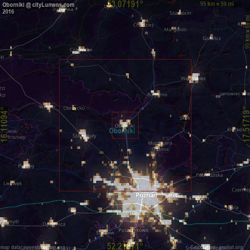
Analysis of Oborniki night lights 2016
Square area 10x10 km:
 0.93%
0.93%90-99
1.98%80-89
0.93%70-79
1.98%60-69
1.72%50-59
2.25%40-49
0.26%30-39
0.53%20-29
0%10-19
0.79%0-9
88.62%Square area 50x50 km:
1.94%90-99
1.63%80-89
0.64%70-79
0.76%60-69
0.88%50-59
1.07%40-49
0.84%30-39
1.45%20-29
2.18%10-19
4.44%0-9
84.16%Clear (daylight) street map image can be seen on geolist.org.
Map coordinates:
53° 4' 18.9" North, 16° 6' 39.4" East
52° 38' 50.6" North, 16° 48' 50.6" East
52° 13' 7.4" North, 17° 31' 1.9" East
Some cities around Oborniki sort by population:
• Poznań
27.9 km =17.3 mi,  163°
163°
• Wągrowiec
31.5 km =19.6 mi,  55°
55°
• Szamotuły
16.4 km =10.2 mi,  256°
256°
• Wronki
30.1 km =18.7 mi,  283°
283°
• Rogoźno
16.7 km =10.4 mi,  45°
45°
• Murowana Goślina
15.5 km =9.6 mi,  121°
121°
• Plewiska
31.2 km =19.4 mi,  180°
180°
• Czerwonak
23.3 km =14.5 mi,  150°
150°
3090403 (p: 17,915)
Sources (retrieved 2019-11-25):
» Earth at Night: Flat Maps 2012, 2016