Sulechów night lights from space
Night Light of Sulechów (Lubusz) from space (Poland) Src. Average luminocity for 10x10km area is 7.4048% and for 50x50km: 3.8447%.
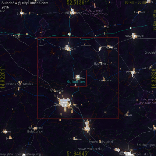
Analysis of Sulechów night lights 2016
Square area 10x10 km:
 1.59%
1.59%90-99
0.66%80-89
1.98%70-79
0.53%60-69
0.79%50-59
0.26%40-49
1.06%30-39
0%20-29
0.53%10-19
0.79%0-9
91.8%Square area 50x50 km:
0.72%90-99
0.74%80-89
0.45%70-79
0.33%60-69
0.3%50-59
0.29%40-49
0.36%30-39
0.21%20-29
1.06%10-19
2.63%0-9
92.91%Clear (daylight) street map image can be seen on geolist.org.
Map coordinates:
52° 30' 49" North, 14° 55' 19.2" East
52° 5' 1" North, 15° 37' 30.5" East
51° 38' 58" North, 16° 19' 41.7" East
Some cities around Sulechów sort by population:
• Zielona Góra
18.4 km =11.4 mi,  206°
206°
• Nowa Sól
31.8 km =19.8 mi,  168°
168°
• Świebodzin
19.3 km =12 mi,  341°
341°
• Wolsztyn
33.8 km =21 mi,  83°
83°
• Krosno Odrzańskie
36.1 km =22.4 mi,  264°
264°
• Kożuchów
37.6 km =23.4 mi,  183°
183°
• Zbąszyń
27.7 km =17.2 mi,  47°
47°
• Zbąszynek
22 km =13.7 mi,  36°
36°
3084241 (p: 18,055)
Sources (retrieved 2019-11-25):
» Earth at Night: Flat Maps 2012, 2016