Piwniczna-Zdrój night lights from space
Night Light of Piwniczna-Zdrój (Lesser Poland) from space (Poland) Src. Average luminocity for 10x10km area is 3.063% and for 50x50km: 3.594%.
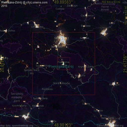
Analysis of Piwniczna-Zdrój night lights 2016
Square area 10x10 km:
 0%
0%90-99
0.7%80-89
0.7%70-79
0.28%60-69
0%50-59
0%40-49
2.1%30-39
0.56%20-29
0.14%10-19
0%0-9
95.52%Square area 50x50 km:
0.47%90-99
0.7%80-89
0.41%70-79
0.29%60-69
0.44%50-59
0.58%40-49
0.64%30-39
0.53%20-29
0.68%10-19
2.09%0-9
93.19%Clear (daylight) street map image can be seen on geolist.org.
Map coordinates:
49° 53' 44.3" North, 20° 0' 40" East
49° 26' 26" North, 20° 42' 51.2" East
48° 58' 52.4" North, 21° 25' 2.5" East
Some cities around Piwniczna-Zdrój sort by population:
• Nowy Sącz
20.2 km =12.6 mi,  356°
356°
• Stará Ľubovňa, SK
15.9 km =9.9 mi,  187°
187°
• Krynica-Zdrój
17.8 km =11.1 mi,  96°
96°
• Stary Sącz
14.8 km =9.2 mi,  337°
337°
• Spišská Belá, SK
33.7 km =20.9 mi,  213°
213°
• Szczawnica
16.7 km =10.4 mi,  263°
263°
• Grybów
26.5 km =16.5 mi,  39°
39°
• Muszyna
16.2 km =10.1 mi,  125°
125°
762106 (p: 5,793)
Sources (retrieved 2019-11-25):
» Earth at Night: Flat Maps 2012, 2016