Radzyń Podlaski night lights from space
Night Light of Radzyń Podlaski (Lublin) from space (Poland) Src. Average luminocity for 10x10km area is 9.2227% and for 50x50km: 1.8024%.
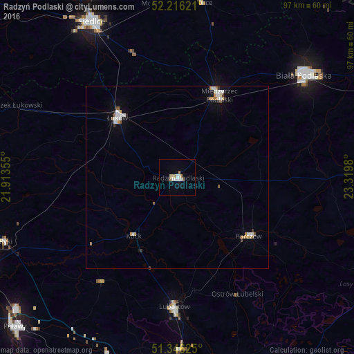
Analysis of Radzyń Podlaski night lights 2016
Square area 10x10 km:
 2.1%
2.1%90-99
1.82%80-89
1.12%70-79
0.84%60-69
0.98%50-59
0.42%40-49
0.56%30-39
0%20-29
0.56%10-19
1.54%0-9
90.06%Square area 50x50 km:
0.35%90-99
0.39%80-89
0.11%70-79
0.3%60-69
0.15%50-59
0.13%40-49
0.12%30-39
0.15%20-29
0.08%10-19
0.57%0-9
97.64%Clear (daylight) street map image can be seen on geolist.org.
Map coordinates:
52° 12' 58.4" North, 21° 54' 48.8" East
51° 46' 60" North, 22° 37' 0" East
51° 20' 46.5" North, 23° 19' 11.3" East
Some cities around Radzyń Podlaski sort by population:
• Siedlce
48.2 km =30 mi,  332°
332°
• Biała Podlaska
44.1 km =27.4 mi,  51°
51°
• Łuków
23 km =14.3 mi,  314°
314°
• Lubartów
35.9 km =22.3 mi,  180°
180°
• Międzyrzec Podlaski
25.3 km =15.7 mi,  26°
26°
• Parczew
25.2 km =15.7 mi,  129°
129°
• Ryki
50.3 km =31.3 mi,  249°
249°
• Łosice
48.1 km =29.9 mi,  8°
8°
760680 (p: 16,071)
Sources (retrieved 2019-11-25):
» Earth at Night: Flat Maps 2012, 2016