Myślenice night lights from space
Night Light of Myślenice (Lesser Poland) from space (Poland) Src. Average luminocity for 10x10km area is 10.6631% and for 50x50km: 10.2479%.
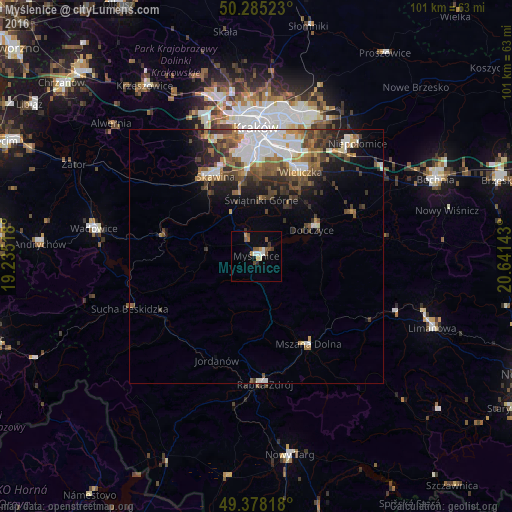
Analysis of Myślenice night lights 2016
Square area 10x10 km:
 1.74%
1.74%90-99
1.34%80-89
0.13%70-79
2.14%60-69
0.13%50-59
3.74%40-49
1.47%30-39
1.6%20-29
0.27%10-19
0.27%0-9
87.17%Square area 50x50 km:
2.23%90-99
1.81%80-89
0.6%70-79
0.86%60-69
1.49%50-59
1.88%40-49
1.9%30-39
1.93%20-29
1.99%10-19
3.78%0-9
81.53%Clear (daylight) street map image can be seen on geolist.org.
Map coordinates:
50° 17' 6.8" North, 19° 14' 6.6" East
49° 50' 1.8" North, 19° 56' 17.9" East
49° 22' 41.4" North, 20° 38' 29.1" East
Some cities around Myślenice sort by population:
• Skawina
17.6 km =10.9 mi,  333°
333°
• Wieliczka
19.3 km =12 mi,  27°
27°
• Rabka-Zdrój
25.1 km =15.6 mi,  175°
175°
• Mszana Dolna
20.4 km =12.7 mi,  150°
150°
• Sułkowice
9.9 km =6.2 mi,  274°
274°
• Dobczyce
12 km =7.5 mi,  64°
64°
• Maków Podhalański
22 km =13.7 mi,  238°
238°
• Jordanów
21.9 km =13.6 mi,  200°
200°
3091256 (p: 17,686)
Sources (retrieved 2019-11-25):
» Earth at Night: Flat Maps 2012, 2016