Kartuzy night lights from space
Night Light of Kartuzy (Pomerania) from space (Poland) Src. Average luminocity for 10x10km area is 7.3409% and for 50x50km: 9.8552%.
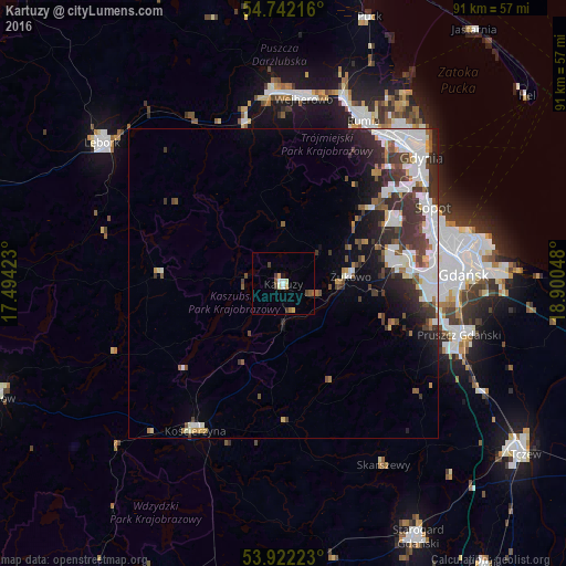
Analysis of Kartuzy night lights 2016
Square area 10x10 km:
 0.63%
0.63%90-99
1.13%80-89
1.13%70-79
1.13%60-69
0.5%50-59
1.5%40-49
1.13%30-39
1.38%20-29
0%10-19
0.5%0-9
90.98%Square area 50x50 km:
2.33%90-99
2.56%80-89
0.46%70-79
0.72%60-69
0.74%50-59
1.01%40-49
1.43%30-39
2.4%20-29
2.51%10-19
3.43%0-9
82.42%Clear (daylight) street map image can be seen on geolist.org.
Map coordinates:
54° 44' 31.8" North, 17° 29' 39.2" East
54° 20' 3.3" North, 18° 11' 50.5" East
53° 55' 20" North, 18° 54' 1.7" East
Some cities around Kartuzy sort by population:
• Gdańsk
29.2 km =18.1 mi,  86°
86°
• Rumia
29.1 km =18.1 mi,  25°
25°
• Sopot
26.4 km =16.4 mi,  63°
63°
• Kościerzyna
27.4 km =17 mi,  210°
210°
• Wielki Kack
24 km =14.9 mi,  51°
51°
• Sierakowice
19.8 km =12.3 mi,  273°
273°
• Luzino
26.4 km =16.4 mi,  347°
347°
• Żukowo
10.9 km =6.8 mi, 85°
3096525 (p: 15,002)
Sources (retrieved 2019-11-25):
» Earth at Night: Flat Maps 2012, 2016