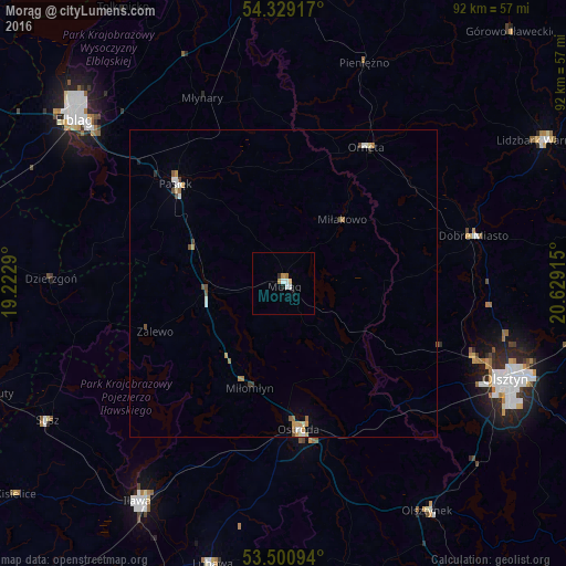
Morąg night lights from space
Night Light of Morąg (Warmia-Masuria) from space (Poland) Src. Average luminocity for 10x10km area is 4.7937% and for 50x50km: 1.0978%.
Analysis of Morąg night lights 2016
Square area 10x10 km:
 1.32%
1.32%90-99
0.93%80-89
0.4%70-79
0.53%60-69
1.06%50-59
0%40-49
0%30-39
0%20-29
0.53%10-19
1.06%0-9
94.18%Square area 50x50 km:
0.16%90-99
0.18%80-89
0.11%70-79
0.2%60-69
0.16%50-59
0.13%40-49
0.19%30-39
0.06%20-29
0.06%10-19
0.09%0-9
98.64%Clear (daylight) street map image can be seen on geolist.org.
Map coordinates:
54° 19' 45" North, 19° 13' 22.4" East
53° 55' 1.6" North, 19° 55' 33.7" East
53° 30' 3.4" North, 20° 37' 44.9" East
Some cities around Morąg sort by population:
• Olsztyn
40.3 km =25 mi,  112°
112°
• Elbląg
42.7 km =26.5 mi,  307°
307°
• Ostróda
24.6 km =15.3 mi,  174°
174°
• Iława
42.7 km =26.5 mi,  213°
213°
• Pasłęk
23.7 km =14.7 mi, 312°
• Dobre Miasto
31.8 km =19.8 mi,  75°
75°
• Orneta
25.8 km =16 mi,  31°
31°
• Dzierzgoń
37.9 km =23.5 mi,  270°
270°
3091462 (p: 14,745)
Sources (retrieved 2019-11-25):
» Earth at Night: Flat Maps 2012, 2016