Lubawka night lights from space
Night Light of Lubawka (Lower Silesia) from space (Poland) Src. Average luminocity for 10x10km area is 1.2794% and for 50x50km: 5.6897%.
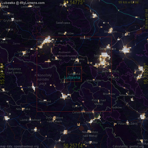
Analysis of Lubawka night lights 2016
Square area 10x10 km:
 0%
0%90-99
0%80-89
0%70-79
0%60-69
0%50-59
0.94%40-49
0.13%30-39
0.53%20-29
0%10-19
1.07%0-9
97.33%Square area 50x50 km:
0.76%90-99
1.06%80-89
0.72%70-79
0.41%60-69
0.82%50-59
0.61%40-49
0.72%30-39
0.62%20-29
1.13%10-19
4.39%0-9
88.75%Clear (daylight) street map image can be seen on geolist.org.
Map coordinates:
51° 8' 51.9" North, 15° 17' 49.7" East
50° 42' 16.4" North, 16° 0' 0.9" East
50° 15' 25.7" North, 16° 42' 12.2" East
Some cities around Lubawka sort by population:
• Wałbrzych
21.3 km =13.2 mi,  69°
69°
• Trutnov, CZ
17.1 km =10.6 mi,  201°
201°
• Kamienna Góra
9 km =5.6 mi,  13°
13°
• Boguszów-Gorce
15.5 km =9.6 mi, 68°
• Kowary
15.2 km =9.4 mi,  310°
310°
• Úpice, CZ
21.4 km =13.3 mi,  177°
177°
• Szczawno-Zdrój
21.1 km =13.1 mi,  58°
58°
• Mysłakowice
21.8 km =13.5 mi, 314°
3093027 (p: 6,404)
Sources (retrieved 2019-11-25):
» Earth at Night: Flat Maps 2012, 2016