Úpice night lights from space
Night Light of Úpice (Královéhradecký kraj) from space (Czech Republic) Src. Average luminocity for 10x10km area is 2.8557% and for 50x50km: 2.7785%.
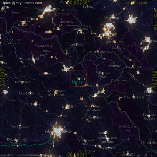
Analysis of Úpice night lights 2016
Square area 10x10 km:
 0%
0%90-99
0%80-89
0.56%70-79
0.14%60-69
0.98%50-59
1.54%40-49
0.14%30-39
0%20-29
0.14%10-19
0.98%0-9
95.52%Square area 50x50 km:
0.22%90-99
0.38%80-89
0.26%70-79
0.35%60-69
0.47%50-59
0.53%40-49
0.38%30-39
0.24%20-29
0.19%10-19
1.04%0-9
95.93%Clear (daylight) street map image can be seen on geolist.org.
Map coordinates:
50° 57' 26.6" North, 15° 18' 46.6" East
50° 30' 44.5" North, 16° 0' 57.9" East
50° 3' 47.3" North, 16° 43' 9.1" East
Some cities around Úpice sort by population:
• Trutnov
9.1 km =5.7 mi,  306°
306°
• Náchod
14.9 km =9.3 mi,  135°
135°
• Dvůr Králové nad Labem
16.9 km =10.5 mi,  237°
237°
• Jaroměř
18.6 km =11.6 mi,  201°
201°
• Kudowa-Zdrój, PL
17.9 km =11.1 mi,  115°
115°
• Červený Kostelec
6.8 km =4.2 mi,  126°
126°
• Hronov
12.3 km =7.6 mi,  107°
107°
• Česká Skalice
13.2 km =8.2 mi,  171°
171°
3063590 (p: 5,959)
Sources (retrieved 2019-11-25):
» Earth at Night: Flat Maps 2012, 2016