Kuźnia Raciborska night lights from space
Night Light of Kuźnia Raciborska (Silesia) from space (Poland) Src. Average luminocity for 10x10km area is 2.7433% and for 50x50km: 12.2671%.
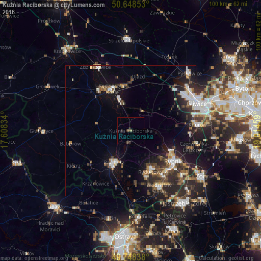
Analysis of Kuźnia Raciborska night lights 2016
Square area 10x10 km:
 0%
0%90-99
0%80-89
0.53%70-79
0%60-69
0.53%50-59
0.53%40-49
0%30-39
2.94%20-29
0.27%10-19
0.94%0-9
94.25%Square area 50x50 km:
1.77%90-99
2.02%80-89
0.79%70-79
1.05%60-69
1.38%50-59
1.58%40-49
2.51%30-39
2.36%20-29
5.68%10-19
8.16%0-9
72.72%Clear (daylight) street map image can be seen on geolist.org.
Map coordinates:
50° 38' 54.7" North, 17° 36' 30" East
50° 12' 2.1" North, 18° 18' 41.3" East
49° 44' 54.2" North, 19° 0' 52.5" East
Some cities around Kuźnia Raciborska sort by population:
• Rybnik
20 km =12.4 mi,  125°
125°
• Kędzierzyn-Koźle
17.7 km =11 mi,  339°
339°
• Racibórz
13.7 km =8.5 mi,  208°
208°
• Rydułtowy
17.5 km =10.9 mi,  154°
154°
• Radlin
20.4 km =12.7 mi,  144°
144°
• Koźle
19.2 km =11.9 mi,  321°
321°
• Pszów
18.8 km =11.7 mi,  161°
161°
• Niedobczyce
19.9 km =12.4 mi, 138°
3094164 (p: 5,472)
Sources (retrieved 2019-11-25):
» Earth at Night: Flat Maps 2012, 2016