Kudowa-Zdrój night lights from space
Night Light of Kudowa-Zdrój (Lower Silesia) from space (Poland) Src. Average luminocity for 10x10km area is 10.1695% and for 50x50km: 2.4716%.
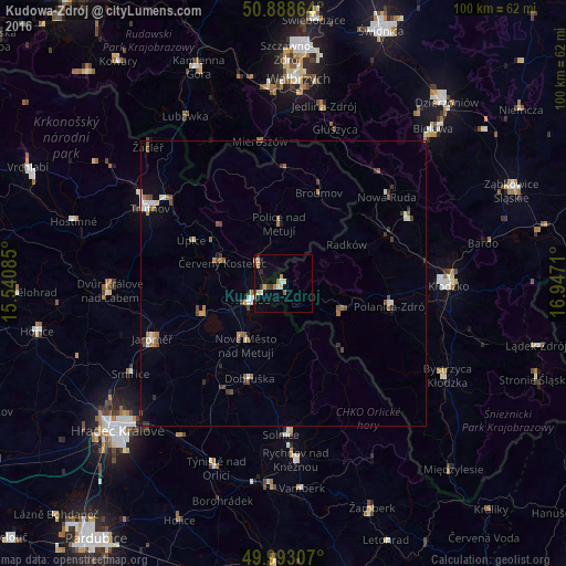
Analysis of Kudowa-Zdrój night lights 2016
Square area 10x10 km:
 0.28%
0.28%90-99
2.1%80-89
1.82%70-79
1.68%60-69
1.12%50-59
0.98%40-49
0.98%30-39
0.84%20-29
1.54%10-19
2.8%0-9
85.85%Square area 50x50 km:
0.21%90-99
0.41%80-89
0.16%70-79
0.24%60-69
0.47%50-59
0.47%40-49
0.39%30-39
0.37%20-29
0.27%10-19
0.5%0-9
96.5%Clear (daylight) street map image can be seen on geolist.org.
Map coordinates:
50° 53' 19.1" North, 15° 32' 27.1" East
50° 26' 34.7" North, 16° 14' 38.3" East
49° 59' 35.1" North, 16° 56' 49.6" East
Some cities around Kudowa-Zdrój sort by population:
• Náchod, CZ
6.4 km =4 mi,  243°
243°
• Nové Město nad Metují, CZ
12.8 km =8 mi,  210°
210°
• Červený Kostelec, CZ
11.3 km =7 mi,  289°
289°
• Broumov, CZ
17 km =10.6 mi,  21°
21°
• Dobruška, CZ
17.8 km =11.1 mi,  199°
199°
• Hronov, CZ
6 km =3.7 mi,  313°
313°
• Česká Skalice, CZ
15.2 km =9.4 mi,  249°
249°
• Szczytna
14.8 km =9.2 mi,  102°
102°
3094303 (p: 10,176)
Sources (retrieved 2019-11-25):
» Earth at Night: Flat Maps 2012, 2016