Broumov night lights from space
Night Light of Broumov (Královéhradecký kraj) from space (Czech Republic) Src. Average luminocity for 10x10km area is 0.6885% and for 50x50km: 4.9121%.
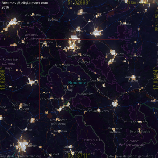
Analysis of Broumov night lights 2016
Square area 10x10 km:
 0%
0%90-99
0%80-89
0%70-79
0%60-69
0.53%50-59
0%40-49
0%30-39
0.53%20-29
0%10-19
0%0-9
98.93%Square area 50x50 km:
0.52%90-99
0.82%80-89
0.62%70-79
0.44%60-69
0.81%50-59
0.64%40-49
0.62%30-39
0.59%20-29
0.82%10-19
2.77%0-9
91.36%Clear (daylight) street map image can be seen on geolist.org.
Map coordinates:
51° 1' 47.9" North, 15° 37' 43.3" East
50° 35' 8.4" North, 16° 19' 54.5" East
50° 8' 13.6" North, 17° 2' 5.8" East
Some cities around Broumov sort by population:
• Nowa Ruda, PL
12 km =7.5 mi,  92°
92°
• Boguszów-Gorce, PL
20.9 km =13 mi,  334°
334°
• Kudowa-Zdrój, PL
17 km =10.6 mi,  201°
201°
• Červený Kostelec
20.8 km =12.9 mi,  234°
234°
• Głuszyca, PL
11.7 km =7.3 mi,  13°
13°
• Hronov
15.8 km =9.8 mi,  221°
221°
• Szczytna, PL
20.8 km =12.9 mi,  156°
156°
• Jedlina-Zdrój, PL
15 km =9.3 mi,  3°
3°
3078577 (p: 8,254)
Sources (retrieved 2019-11-25):
» Earth at Night: Flat Maps 2012, 2016