Kozienice night lights from space
Night Light of Kozienice (Mazovia) from space (Poland) Src. Average luminocity for 10x10km area is 12.5027% and for 50x50km: 3.7365%.
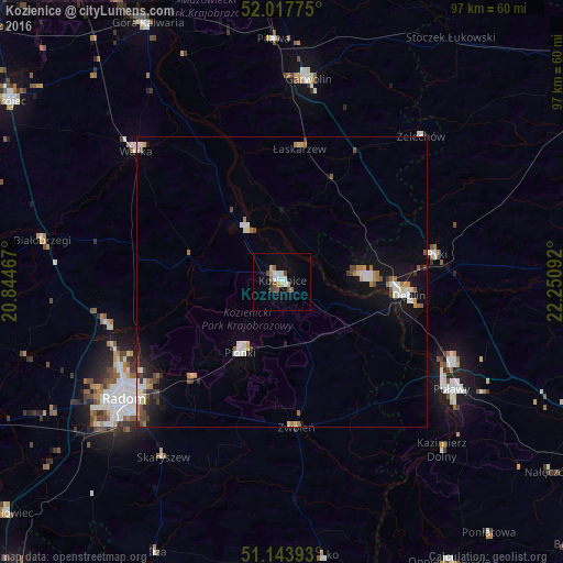
Analysis of Kozienice night lights 2016
Square area 10x10 km:
100  2.14%
2.14%
90-99 2.14%
80-89 1.07%
70-79 1.6%
60-69 1.2%
50-59 1.2%
40-49 2.81%
30-39 0.27%
20-29 0.4%
10-19 3.34%
0-9 83.82%
2.14%90-99
2.14%80-89
1.07%70-79
1.6%60-69
1.2%50-59
1.2%40-49
2.81%30-39
0.27%20-29
0.4%10-19
3.34%0-9
83.82%Square area 50x50 km:
100 0.45%
90-99 0.71%
80-89 0.43%
70-79 0.34%
60-69 0.55%
50-59 0.33%
40-49 0.56%
30-39 0.39%
20-29 0.36%
10-19 2.64%
0-9 93.25%
0.45%90-99
0.71%80-89
0.43%70-79
0.34%60-69
0.55%50-59
0.33%40-49
0.56%30-39
0.39%20-29
0.36%10-19
2.64%0-9
93.25%Clear (daylight) street map image can be seen on geolist.org.
Map coordinates:
52° 1' 3.9" North, 20° 50' 40.8" East
51° 34' 58.6" North, 21° 32' 52" East
51° 8' 38.1" North, 22° 15' 3.3" East
Some cities around Kozienice sort by population:
• Radom
34.2 km =21.3 mi,  234°
234°
• Puławy
34.6 km =21.5 mi,  122°
122°
• Pionki
13.7 km =8.5 mi,  209°
209°
• Dęblin
20.9 km =13 mi,  97°
97°
• Garwolin
35.3 km =21.9 mi,  7°
7°
• Warka
33.3 km =20.7 mi,  312°
312°
• Ryki
27 km =16.8 mi,  79°
79°
• Zwoleń
25.4 km =15.8 mi,  173°
173°
767814 (p: 18,677)
Sources (retrieved 2019-11-25):
» Earth at Night: Flat Maps 2012, 2016