Jedlina-Zdrój night lights from space
Night Light of Jedlina-Zdrój (Lower Silesia) from space (Poland) Src. Average luminocity for 10x10km area is 8.766% and for 50x50km: 5.7007%.
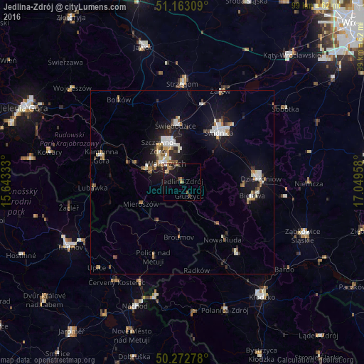
Analysis of Jedlina-Zdrój night lights 2016
Square area 10x10 km:
 0%
0%90-99
0.67%80-89
2.14%70-79
0.27%60-69
2.01%50-59
1.07%40-49
2.14%30-39
0%20-29
3.21%10-19
9.49%0-9
79.01%Square area 50x50 km:
0.81%90-99
1.16%80-89
0.52%70-79
0.43%60-69
0.7%50-59
0.6%40-49
0.58%30-39
0.63%20-29
1.18%10-19
4.98%0-9
88.42%Clear (daylight) street map image can be seen on geolist.org.
Map coordinates:
51° 9' 47.1" North, 15° 38' 36" East
50° 43' 12.2" North, 16° 20' 47.2" East
50° 16' 22" North, 17° 2' 58.5" East
Some cities around Jedlina-Zdrój sort by population:
• Wałbrzych
7.2 km =4.5 mi,  322°
322°
• Świdnica
17 km =10.6 mi,  35°
35°
• Świebodzice
15.6 km =9.7 mi,  353°
353°
• Boguszów-Gorce
10.7 km =6.6 mi,  291°
291°
• Pieszyce
16.6 km =10.3 mi,  92°
92°
• Broumov, CZ
15 km =9.3 mi,  183°
183°
• Głuszyca
4 km =2.5 mi,  153°
153°
• Szczawno-Zdrój
11.2 km =7 mi,  325°
325°
3097301 (p: 5,062)
Sources (retrieved 2019-11-25):
» Earth at Night: Flat Maps 2012, 2016