Bychawa night lights from space
Night Light of Bychawa (Lublin) from space (Poland) Src. Average luminocity for 10x10km area is 3.4733% and for 50x50km: 5.5413%.
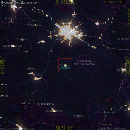
Analysis of Bychawa night lights 2016
Square area 10x10 km:
 0.8%
0.8%90-99
1.07%80-89
0.67%70-79
0.13%60-69
0%50-59
0%40-49
0.27%30-39
0.8%20-29
0%10-19
0%0-9
96.26%Square area 50x50 km:
1.38%90-99
1.14%80-89
0.41%70-79
0.38%60-69
0.65%50-59
0.54%40-49
0.61%30-39
0.93%20-29
1.3%10-19
2.35%0-9
90.32%Clear (daylight) street map image can be seen on geolist.org.
Map coordinates:
51° 27' 22.7" North, 21° 49' 47.4" East
51° 0' 57.9" North, 22° 31' 58.7" East
50° 34' 17.9" North, 23° 14' 9.9" East
Some cities around Bychawa sort by population:
• Lublin
26.1 km =16.2 mi,  5°
5°
• Świdnik
25.3 km =15.7 mi,  26°
26°
• Kraśnik
23.8 km =14.8 mi,  244°
244°
• Łęczna
39.9 km =24.8 mi,  37°
37°
• Janów Lubelski
35.4 km =22 mi,  194°
194°
• Poniatowa
33.5 km =20.8 mi,  302°
302°
• Opole Lubelskie
42 km =26.1 mi,  290°
290°
• Bełżyce
24.9 km =15.5 mi,  314°
314°
774730 (p: 5,297)
Sources (retrieved 2019-11-25):
» Earth at Night: Flat Maps 2012, 2016