Loralai night lights from space
Night Light of Loralai (Balochistan) from space (Pakistan) Src. Average luminocity for 10x10km area is 2.8993% and for 50x50km: 0.1691%.
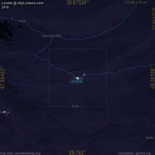
Analysis of Loralai night lights 2016
Square area 10x10 km:
 0%
0%90-99
2.2%80-89
0%70-79
0%60-69
0%50-59
0%40-49
0.73%30-39
0%20-29
0%10-19
0%0-9
97.07%Square area 50x50 km:
0%90-99
0.12%80-89
0%70-79
0%60-69
0%50-59
0.01%40-49
0.05%30-39
0%20-29
0%10-19
0.03%0-9
99.79%Clear (daylight) street map image can be seen on geolist.org.
Map coordinates:
30° 58' 30.9" North, 67° 53' 41.4" East
30° 22' 13.8" North, 68° 35' 52.6" East
29° 45' 43.2" North, 69° 18' 3.9" East
Some cities around Loralai sort by population:
• Sibi
115.3 km =71.6 mi,  217°
217°
• Mach
134.3 km =83.5 mi,  245°
245°
• Kohlu
82.1 km =51 mi,  129°
129°
• Harnai
70.1 km =43.6 mi,  244°
244°
• Barkhan
103.5 km =64.3 mi,  120°
120°
• Alik Ghund
104 km =64.6 mi,  277°
277°
• Khadan Khak
94.9 km =59 mi,  296°
296°
• Duki
24.3 km =15.1 mi,  185°
185°
1171868 (p: 37,787)
Sources (retrieved 2019-11-25):
» Earth at Night: Flat Maps 2012, 2016