Dhaunkal night lights from space
Night Light of Dhaunkal (Punjab) from space (Pakistan) Src. Average luminocity for 10x10km area is 17.5842% and for 50x50km: 11.2153%.
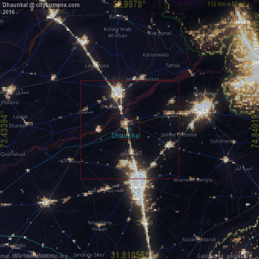
Analysis of Dhaunkal night lights 2016
Square area 10x10 km:
 0%
0%90-99
2.01%80-89
1.83%70-79
1.83%60-69
4.58%50-59
3.66%40-49
5.68%30-39
3.3%20-29
2.75%10-19
6.04%0-9
68.32%Square area 50x50 km:
0.68%90-99
2.58%80-89
1.04%70-79
0.93%60-69
1.28%50-59
1.74%40-49
2.41%30-39
1.8%20-29
3.2%10-19
7.38%0-9
76.96%Clear (daylight) street map image can be seen on geolist.org.
Map coordinates:
32° 59' 52.1" North, 73° 26' 2.2" East
32° 24' 22.1" North, 74° 8' 13.4" East
31° 48' 38" North, 74° 50' 24.7" East
Some cities around Dhaunkal sort by population:
• Gujrat
19.6 km =12.2 mi,  342°
342°
• Daska Kalan
22 km =13.7 mi,  114°
114°
• Wazirabad
4.4 km =2.7 mi, 338°
• Sambrial
21.8 km =13.5 mi,  68°
68°
• Kunjah
20.5 km =12.7 mi,  312°
312°
• Bhopalwala
21.4 km =13.3 mi,  82°
82°
• Sodhri
7.5 km =4.7 mi,  34°
34°
• Begowala
12.8 km =8 mi, 73°
1180071 (p: 12,117)
Sources (retrieved 2019-11-25):
» Earth at Night: Flat Maps 2012, 2016