Begowala night lights from space
Night Light of Begowala (Punjab) from space (Pakistan) Src. Average luminocity for 10x10km area is 1.1245% and for 50x50km: 13.173%.
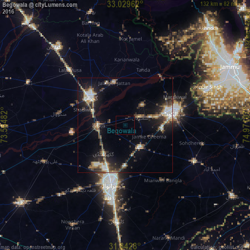
Analysis of Begowala night lights 2016
Square area 10x10 km:
 0%
0%90-99
0%80-89
0%70-79
0%60-69
0%50-59
0%40-49
0%30-39
0.92%20-29
1.65%10-19
0.73%0-9
96.7%Square area 50x50 km:
0.67%90-99
2.88%80-89
1.33%70-79
1.01%60-69
1.52%50-59
2.05%40-49
2.89%30-39
2.42%20-29
3.98%10-19
9.49%0-9
71.74%Clear (daylight) street map image can be seen on geolist.org.
Map coordinates:
33° 1' 46.6" North, 73° 33' 53.4" East
32° 26' 17.4" North, 74° 16' 4.6" East
31° 50' 34.1" North, 74° 58' 15.9" East
Some cities around Begowala sort by population:
• Gujrat
23.6 km =14.7 mi,  309°
309°
• Daska Kalan
14.8 km =9.2 mi,  148°
148°
• Wazirabad
13.9 km =8.6 mi,  272°
272°
• Jalalpur Jattan
23.3 km =14.5 mi,  345°
345°
• Sambrial
9.2 km =5.7 mi,  60°
60°
• Bhopalwala
9 km =5.6 mi,  96°
96°
• Sodhri
8.5 km =5.3 mi,  288°
288°
• Dhaunkal
12.8 km =8 mi,  253°
253°
1183018 (p: 9,259)
Sources (retrieved 2019-11-25):
» Earth at Night: Flat Maps 2012, 2016