Dhanot night lights from space
Night Light of Dhanot (Punjab) from space (Pakistan) Src. Average luminocity for 10x10km area is 3.3598% and for 50x50km: 8.7078%.
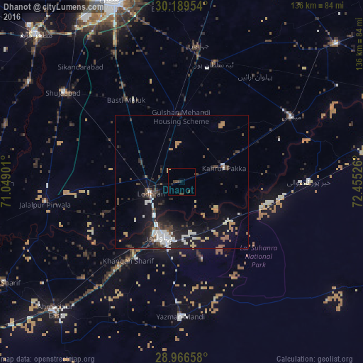
Analysis of Dhanot night lights 2016
Square area 10x10 km:
 0%
0%90-99
0%80-89
0.57%70-79
0.19%60-69
0%50-59
0%40-49
3.03%30-39
1.52%20-29
1.52%10-19
0%0-9
93.18%Square area 50x50 km:
1.15%90-99
1.77%80-89
0.6%70-79
0.82%60-69
0.9%50-59
0.43%40-49
1.81%30-39
1.14%20-29
2.37%10-19
7.62%0-9
81.38%Clear (daylight) street map image can be seen on geolist.org.
Map coordinates:
30° 11' 22.3" North, 71° 2' 56.4" East
29° 34' 47.7" North, 71° 45' 7.7" East
28° 57' 59.7" North, 72° 27' 18.9" East
Some cities around Dhanot sort by population:
• Bahawalpur
21.6 km =13.4 mi,  200°
200°
• Lodhran
12.7 km =7.9 mi,  246°
246°
• Kahror Pakka
16.4 km =10.2 mi,  72°
72°
• Mailsi
47.6 km =29.6 mi,  58°
58°
• Jalalpur Pirwala
51.9 km =32.2 mi,  260°
260°
• Dunyapur
24.8 km =15.4 mi,  358°
358°
• Khairpur Tamewah
47 km =29.2 mi,  89°
89°
• Yazman
51 km =31.7 mi,  180°
180°
1180133 (p: 18,729)
Sources (retrieved 2019-11-25):
» Earth at Night: Flat Maps 2012, 2016