Sibulan night lights from space
Night Light of Sibulan (Davao) from space (Philippines) Src. Average luminocity for 10x10km area is 6.8961% and for 50x50km: 10.8223%.
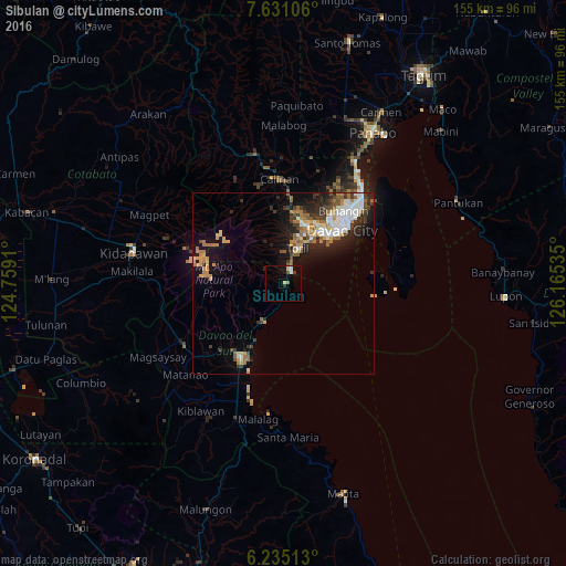
Analysis of Sibulan night lights 2016
Square area 10x10 km:
100  1.08%
1.08%
90-99 0.65%
80-89 1.73%
70-79 0%
60-69 1.3%
50-59 0.43%
40-49 1.3%
30-39 0.43%
20-29 1.3%
10-19 1.3%
0-9 90.48%
1.08%90-99
0.65%80-89
1.73%70-79
0%60-69
1.3%50-59
0.43%40-49
1.3%30-39
0.43%20-29
1.3%10-19
1.3%0-9
90.48%Square area 50x50 km:
100 1.9%
90-99 1.55%
80-89 0.91%
70-79 1.82%
60-69 1.8%
50-59 1.35%
40-49 1.03%
30-39 1.72%
20-29 3.03%
10-19 5.89%
0-9 79%
1.9%90-99
1.55%80-89
0.91%70-79
1.82%60-69
1.8%50-59
1.35%40-49
1.03%30-39
1.72%20-29
3.03%10-19
5.89%0-9
79%Clear (daylight) street map image can be seen on geolist.org.
Map coordinates:
7° 37' 51.8" North, 124° 45' 32.8" East
6° 56' 1" North, 125° 27' 44" East
6° 14' 6.5" North, 126° 9' 55.3" East
Some cities around Sibulan sort by population:
• Davao
22.7 km =14.1 mi,  46°
46°
• Astorga
3 km =1.9 mi,  193°
193°
• Baracatan
6.4 km =4 mi,  306°
306°
• Coronon
6.2 km =3.9 mi, 193°
• Inawayan
3.3 km =2.1 mi,  22°
22°
• Tuban
14.9 km =9.3 mi,  213°
213°
• Sirib
23 km =14.3 mi,  344°
344°
• Bato
12.2 km =7.6 mi,  5°
5°
1686732 (p: 9,021)
Sources (retrieved 2019-11-25):
» Earth at Night: Flat Maps 2012, 2016