San Francisco night lights from space
Night Light of San Francisco (Central Visayas) from space (Philippines) Src. Average luminocity for 10x10km area is 0.6074% and for 50x50km: 0.035%.
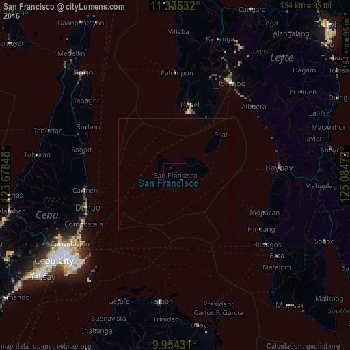
Analysis of San Francisco night lights 2016
Square area 10x10 km:
 0%
0%90-99
0%80-89
0%70-79
0%60-69
0%50-59
0%40-49
0.62%30-39
0.21%20-29
0.83%10-19
0%0-9
98.35%Square area 50x50 km:
0%90-99
0%80-89
0%70-79
0%60-69
0%50-59
0%40-49
0.03%30-39
0.01%20-29
0.03%10-19
0%0-9
99.93%Clear (daylight) street map image can be seen on geolist.org.
Map coordinates:
11° 20' 10.8" North, 123° 40' 42.5" East
10° 38' 46" North, 124° 22' 53.8" East
9° 57' 15.5" North, 125° 5' 5" East
Some cities around San Francisco sort by population:
• Danao
41.2 km =25.6 mi,  250°
250°
• Cogan
40.2 km =25 mi,  261°
261°
• Palompon
45 km =28 mi,  0°
0°
• Isabel
31.7 km =19.7 mi,  10°
10°
• Catmon
42.4 km =26.3 mi,  280°
280°
• Balogo
44.8 km =27.8 mi,  53°
53°
• Matlang
28.3 km =17.6 mi,  16°
16°
• Esperanza
9.5 km =5.9 mi,  308°
308°
1690011 (p: 8,989)
Sources (retrieved 2019-11-25):
» Earth at Night: Flat Maps 2012, 2016