Salawagan night lights from space
Night Light of Salawagan (Northern Mindanao) from space (Philippines) Src. Average luminocity for 10x10km area is 1.157% and for 50x50km: 0.9239%.
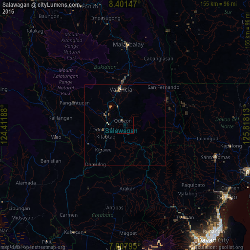
Analysis of Salawagan night lights 2016
Square area 10x10 km:
 0%
0%90-99
0%80-89
0%70-79
0%60-69
0.83%50-59
0%40-49
0%30-39
0.83%20-29
0%10-19
0.83%0-9
97.52%Square area 50x50 km:
0.03%90-99
0.07%80-89
0.09%70-79
0.14%60-69
0.15%50-59
0.22%40-49
0.29%30-39
0.19%20-29
0.2%10-19
0.17%0-9
98.45%Clear (daylight) street map image can be seen on geolist.org.
Map coordinates:
8° 24' 5.3" North, 124° 24' 42.8" East
7° 42' 19" North, 125° 6' 54" East
7° 0' 28.6" North, 125° 49' 5.3" East
Some cities around Salawagan sort by population:
• NIA Valencia
22.5 km =14 mi,  354°
354°
• Maramag
13.7 km =8.5 mi,  298°
298°
• Quezon
3.3 km =2.1 mi,  327°
327°
• Don Carlos
12.4 km =7.7 mi,  256°
256°
• Dologon
17 km =10.6 mi, 332°
• Kadingilan
25.5 km =15.8 mi,  243°
243°
• San Jose
6 km =3.7 mi,  305°
305°
• Kibawe
20.7 km =12.9 mi,  222°
222°
1690937 (p: 6,508)
Sources (retrieved 2019-11-25):
» Earth at Night: Flat Maps 2012, 2016