Pura night lights from space
Night Light of Pura (Central Luzon) from space (Philippines) Src. Average luminocity for 10x10km area is 7.1883% and for 50x50km: 4.6877%.
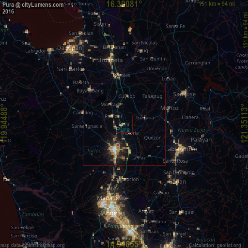
Analysis of Pura night lights 2016
Square area 10x10 km:
 0%
0%90-99
0.87%80-89
0.43%70-79
0.43%60-69
1.52%50-59
0.65%40-49
2.81%30-39
2.38%20-29
0.43%10-19
0.43%0-9
90.04%Square area 50x50 km:
0.06%90-99
0.23%80-89
0.43%70-79
0.94%60-69
1.19%50-59
0.53%40-49
0.96%30-39
1.28%20-29
1.45%10-19
3.5%0-9
89.41%Clear (daylight) street map image can be seen on geolist.org.
Map coordinates:
16° 18' 2.9" North, 119° 56' 41.6" East
15° 37' 29.3" North, 120° 38' 52.8" East
14° 56' 47.6" North, 121° 21' 4.1" East
Some cities around Pura sort by population:
• Paniqui
8.7 km =5.4 mi,  304°
304°
• Gerona
5.7 km =3.5 mi,  249°
249°
• Guimba
13.5 km =8.4 mi,  72°
72°
• Burgos
14.1 km =8.8 mi,  324°
324°
• Ramos
4.6 km =2.9 mi,  350°
350°
• San Nicolas
5.5 km =3.4 mi,  146°
146°
• Nampicuan
12.1 km =7.5 mi, 348°
• Baquero Norte
14.3 km =8.9 mi, 315°
1692377 (p: 6,928)
Sources (retrieved 2019-11-25):
» Earth at Night: Flat Maps 2012, 2016