New Visayas night lights from space
Night Light of New Visayas (Davao) from space (Philippines) Src. Average luminocity for 10x10km area is 6.3485% and for 50x50km: 2.5143%.
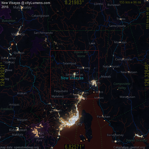
Analysis of New Visayas night lights 2016
Square area 10x10 km:
 0%
0%90-99
0.87%80-89
0%70-79
0.87%60-69
0%50-59
1.08%40-49
3.03%30-39
4.33%20-29
1.73%10-19
0.87%0-9
87.23%Square area 50x50 km:
0.13%90-99
0.25%80-89
0.38%70-79
0.31%60-69
0.28%50-59
0.47%40-49
0.53%30-39
0.65%20-29
0.52%10-19
1.24%0-9
95.25%Clear (daylight) street map image can be seen on geolist.org.
Map coordinates:
8° 13' 11.4" North, 124° 55' 12.8" East
7° 31' 24" North, 125° 37' 24" East
6° 49' 32.6" North, 126° 19' 35.3" East
Some cities around New Visayas sort by population:
• Cabayangan
17.7 km =11 mi,  136°
136°
• Cambanugoy
14.7 km =9.1 mi,  82°
82°
• Santo Niño
11.2 km =7 mi,  1°
1°
• Sampao
8.9 km =5.5 mi,  27°
27°
• Alejal
16 km =9.9 mi,  165°
165°
• Tubod
17 km =10.6 mi, 172°
• Magatos
11.9 km =7.4 mi,  72°
72°
• La Libertad
5.5 km =3.4 mi,  151°
151°
1697736 (p: 14,758)
Sources (retrieved 2019-11-25):
» Earth at Night: Flat Maps 2012, 2016