Mamungan night lights from space
Night Light of Mamungan (Northern Mindanao) from space (Philippines) Src. Average luminocity for 10x10km area is 1.157% and for 50x50km: 2.7642%.
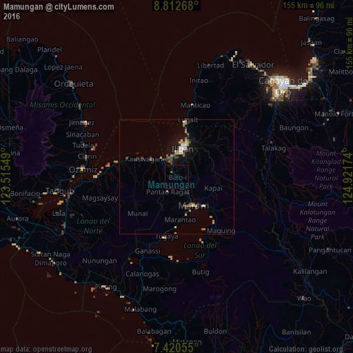
Analysis of Mamungan night lights 2016
Square area 10x10 km:
 0%
0%90-99
0%80-89
0%70-79
0%60-69
0.41%50-59
0.41%40-49
0%30-39
0%20-29
0%10-19
0%0-9
99.17%Square area 50x50 km:
0.23%90-99
0.21%80-89
0.39%70-79
0.4%60-69
0.49%50-59
0.48%40-49
0.28%30-39
0.51%20-29
0.37%10-19
2.01%0-9
94.64%Clear (daylight) street map image can be seen on geolist.org.
Map coordinates:
8° 48' 45.6" North, 123° 30' 55.8" East
8° 7' 2" North, 124° 13' 7" East
7° 25' 14" North, 124° 55' 18.3" East
Some cities around Mamungan sort by population:
• Iligan
12.7 km =7.9 mi,  12°
12°
• Mantampay
5.5 km =3.4 mi,  357°
357°
• Marawi City
14.6 km =9.1 mi,  150°
150°
• Boroon
8.6 km =5.3 mi,  327°
327°
• Kauswagan
16.9 km =10.5 mi,  299°
299°
• Linamon
9.8 km =6.1 mi,  321°
321°
• Maria Cristina
5.7 km =3.5 mi,  343°
343°
• Libertad
14.9 km =9.3 mi, 6°
1727889 (p: 7,700)
Sources (retrieved 2019-11-25):
» Earth at Night: Flat Maps 2012, 2016