Loon night lights from space
Night Light of Loon (Central Visayas) from space (Philippines) Src. Average luminocity for 10x10km area is 0.4957% and for 50x50km: 1.3854%.
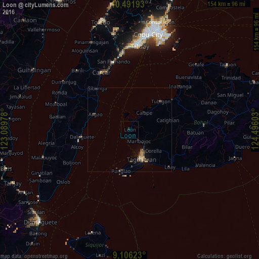
Analysis of Loon night lights 2016
Square area 10x10 km:
 0%
0%90-99
0%80-89
0%70-79
0%60-69
0%50-59
0%40-49
0%30-39
0.87%20-29
0%10-19
0.87%0-9
98.27%Square area 50x50 km:
0.06%90-99
0.04%80-89
0.13%70-79
0.12%60-69
0.37%50-59
0.18%40-49
0.39%30-39
0.45%20-29
0.38%10-19
0.55%0-9
97.34%Clear (daylight) street map image can be seen on geolist.org.
Map coordinates:
10° 29' 30.9" North, 123° 5' 23.2" East
9° 47' 59.3" North, 123° 47' 34.4" East
9° 6' 22.4" North, 124° 29' 45.7" East
Some cities around Loon sort by population:
• Tagbilaran City
17.3 km =10.7 mi,  157°
157°
• Danao
27.6 km =17.1 mi,  188°
188°
• Tibigan
25.1 km =15.6 mi,  47°
47°
• San Isidro
16.3 km =10.1 mi,  37°
37°
• Bogo
25.8 km =16 mi,  284°
284°
• Dalaguete
28.6 km =17.8 mi,  261°
261°
• Panglao
25.2 km =15.7 mi, 191°
• Argao
23.4 km =14.5 mi,  292°
292°
1705581 (p: 9,484)
Sources (retrieved 2019-11-25):
» Earth at Night: Flat Maps 2012, 2016