Guadalupe night lights from space
Night Light of Guadalupe (Western Visayas) from space (Philippines) Src. Average luminocity for 10x10km area is 5.4959% and for 50x50km: 0.8145%.
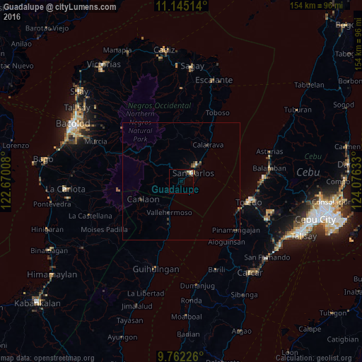
Analysis of Guadalupe night lights 2016
Square area 10x10 km:
 0.83%
0.83%90-99
0.83%80-89
1.65%70-79
0.83%60-69
0%50-59
0%40-49
0%30-39
1.65%20-29
1.65%10-19
0%0-9
92.56%Square area 50x50 km:
0.05%90-99
0.05%80-89
0.17%70-79
0.1%60-69
0.04%50-59
0.06%40-49
0.14%30-39
0.29%20-29
0.26%10-19
0.14%0-9
98.69%Clear (daylight) street map image can be seen on geolist.org.
Map coordinates:
11° 8' 42.5" North, 122° 40' 12.3" East
10° 27' 16.1" North, 123° 22' 23.5" East
9° 45' 44.1" North, 124° 4' 34.8" East
Some cities around Guadalupe sort by population:
• Ualog
13.5 km =8.4 mi,  9°
9°
• Codcod
13.6 km =8.5 mi,  274°
274°
• Buluangan
8.4 km =5.2 mi,  207°
207°
• Quezon
12.5 km =7.8 mi,  260°
260°
• Vallehermoso
14.3 km =8.9 mi,  201°
201°
• Palampas
9.4 km =5.8 mi,  33°
33°
• Malaiba
14.8 km =9.2 mi, 204°
• Punao
12.9 km =8 mi,  17°
17°
1712640 (p: 11,053)
Sources (retrieved 2019-11-25):
» Earth at Night: Flat Maps 2012, 2016