General Emilio Aguinaldo night lights from space
Night Light of General Emilio Aguinaldo (Calabarzon) from space (Philippines) Src. Average luminocity for 10x10km area is 0.2489% and for 50x50km: 14.8285%.
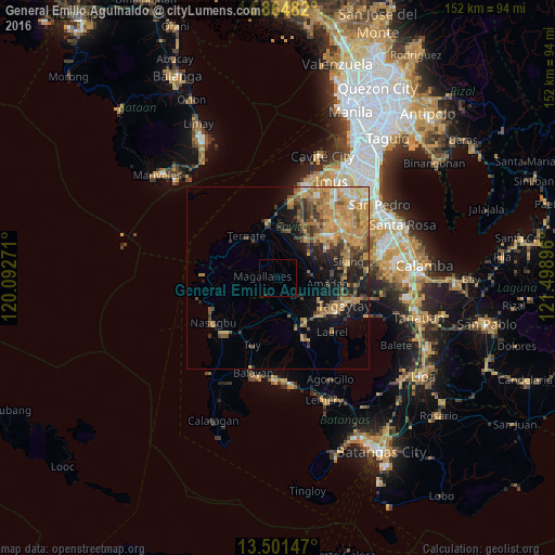
Analysis of General Emilio Aguinaldo night lights 2016
Square area 10x10 km:
 0%
0%90-99
0%80-89
0%70-79
0%60-69
0%50-59
0%40-49
0%30-39
0.43%20-29
0%10-19
0%0-9
99.57%Square area 50x50 km:
0.51%90-99
1.1%80-89
1.6%70-79
5.37%60-69
4.11%50-59
1.89%40-49
2.94%30-39
2.04%20-29
2.3%10-19
6.83%0-9
71.31%Clear (daylight) street map image can be seen on geolist.org.
Map coordinates:
14° 51' 53.4" North, 120° 5' 33.8" East
14° 11' 3" North, 120° 47' 45" East
13° 30' 5.3" North, 121° 29' 56.3" East
Some cities around General Emilio Aguinaldo sort by population:
• Indang
8.8 km =5.5 mi,  81°
81°
• Maragondon
11.7 km =7.3 mi,  327°
327°
• Mendez-Nuñez
13.4 km =8.3 mi,  117°
117°
• Amadeo
13.9 km =8.6 mi,  96°
96°
• Palangue
11.2 km =7 mi,  8°
8°
• Alfonso
7.9 km =4.9 mi,  127°
127°
• Aga
9.8 km =6.1 mi,  175°
175°
• Pantijan No 2
5.5 km =3.4 mi, 5°
1713053 (p: 12,244)
Sources (retrieved 2019-11-25):
» Earth at Night: Flat Maps 2012, 2016