Vice night lights from space
Night Light of Vice (Piura) from space (Peru) Src. Average luminocity for 10x10km area is 19.5021% and for 50x50km: 6.7943%.
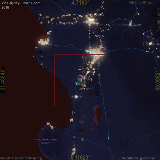
Analysis of Vice night lights 2016
Square area 10x10 km:
100  0%
0%
90-99 0%
80-89 4.13%
70-79 4.96%
60-69 3.93%
50-59 2.69%
40-49 4.96%
30-39 3.72%
20-29 3.72%
10-19 8.47%
0-9 63.43%
0%90-99
0%80-89
4.13%70-79
4.96%60-69
3.93%50-59
2.69%40-49
4.96%30-39
3.72%20-29
3.72%10-19
8.47%0-9
63.43%Square area 50x50 km:
100 0.46%
90-99 0.59%
80-89 1.28%
70-79 0.87%
60-69 1.04%
50-59 0.82%
40-49 0.93%
30-39 1.48%
20-29 2.19%
10-19 5.43%
0-9 84.91%
0.46%90-99
0.59%80-89
1.28%70-79
0.87%60-69
1.04%50-59
0.82%40-49
0.93%30-39
1.48%20-29
2.19%10-19
5.43%0-9
84.91%Clear (daylight) street map image can be seen on geolist.org.
Map coordinates:
4° 42' 58.7" South, 81° 29' 11.3" West
5° 25' 0" South, 80° 46' 60" West
6° 6' 58.4" South, 80° 4' 48.8" West
Some cities around Vice sort by population:
• Piura
29.8 km =18.5 mi,  34°
34°
• Sullana
58 km =36 mi,  10°
10°
• Catacaos
20 km =12.4 mi, 33°
• Paita
51.7 km =32.1 mi,  314°
314°
• La Unión
4.8 km =3 mi,  70°
70°
• Sechura
16.2 km =10.1 mi,  195°
195°
• Salinera Colán
52.9 km =32.9 mi,  323°
323°
• Bernal
5.2 km =3.2 mi,  135°
135°
3690935 (p: 12,915)
Sources (retrieved 2019-11-25):
» Earth at Night: Flat Maps 2012, 2016