Pilcomay night lights from space
Night Light of Pilcomay (Junin) from space (Peru) Src. Average luminocity for 10x10km area is 65.9897% and for 50x50km: 9.9043%.
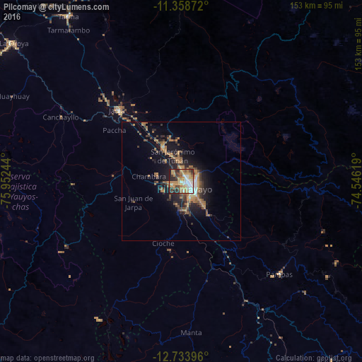
Analysis of Pilcomay night lights 2016
Square area 10x10 km:
 12.6%
12.6%90-99
11.36%80-89
7.64%70-79
23.14%60-69
10.74%50-59
3.31%40-49
8.06%30-39
8.88%20-29
12.6%10-19
1.65%0-9
0%Square area 50x50 km:
0.75%90-99
0.9%80-89
0.47%70-79
2.47%60-69
2.42%50-59
1.33%40-49
1.72%30-39
1.79%20-29
2.78%10-19
6.99%0-9
78.39%Clear (daylight) street map image can be seen on geolist.org.
Map coordinates:
11° 21' 31.4" South, 75° 57' 8.8" West
12° 2' 50" South, 75° 14' 57.5" West
12° 44' 2.3" South, 74° 32' 46.3" West
Some cities around Pilcomay sort by population:
• Huancayo
5.2 km =3.2 mi,  112°
112°
• Jauja
40.4 km =25.1 mi,  318°
318°
• Concepción
16 km =9.9 mi,  333°
333°
• Chupaca
4.3 km =2.7 mi,  239°
239°
• San Jerónimo
10.8 km =6.7 mi,  339°
339°
• Sicaya
4 km =2.5 mi,  292°
292°
• San Agustin
8.4 km =5.2 mi,  355°
355°
• Huayucachi
9.7 km =6 mi,  169°
169°
3932282 (p: 8,169)
Sources (retrieved 2019-11-25):
» Earth at Night: Flat Maps 2012, 2016