Papayal night lights from space
Night Light of Papayal (Tumbes) from space (Peru) Src. Average luminocity for 10x10km area is 0% and for 50x50km: 0.2241%.
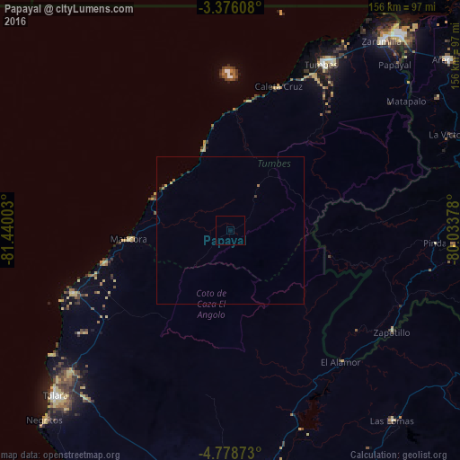
Analysis of Papayal night lights 2016
Square area 10x10 km:
100  0%
0%
90-99 0%
80-89 0%
70-79 0%
60-69 0%
50-59 0%
40-49 0%
30-39 0%
20-29 0%
10-19 0%
0-9 100%
0%90-99
0%80-89
0%70-79
0%60-69
0%50-59
0%40-49
0%30-39
0%20-29
0%10-19
0%0-9
100%Square area 50x50 km:
100 0%
90-99 0%
80-89 0.07%
70-79 0.03%
60-69 0.08%
50-59 0%
40-49 0%
30-39 0.05%
20-29 0.12%
10-19 0.05%
0-9 99.61%
0%90-99
0%80-89
0.07%70-79
0.03%60-69
0.08%50-59
0%40-49
0%30-39
0.05%20-29
0.12%10-19
0.05%0-9
99.61%Clear (daylight) street map image can be seen on geolist.org.
Map coordinates:
3° 22' 33.9" South, 81° 26' 24.1" West
4° 4' 39.8" South, 80° 44' 12.8" West
4° 46' 43.4" South, 80° 2' 1.6" West
Some cities around Papayal sort by population:
• Tumbes
65 km =40.4 mi,  29°
29°
• Talara
81.3 km =50.5 mi,  226°
226°
• La Breita
25.9 km =16.1 mi,  219°
219°
• Zarumilla
82 km =51 mi,  38°
38°
• Zorritos
44.6 km =27.7 mi,  8°
8°
• Las Lomas
84 km =52.2 mi,  139°
139°
• El Alto
57.3 km =35.6 mi,  248°
248°
• Máncora
34.6 km =21.5 mi,  264°
264°
3814639 (p: 5,484)
Sources (retrieved 2019-11-25):
» Earth at Night: Flat Maps 2012, 2016