Puerto Armuelles night lights from space
Night Light of Puerto Armuelles (Chiriquí) from space (Panama) Src. Average luminocity for 10x10km area is 8.7603% and for 50x50km: 0.9514%.
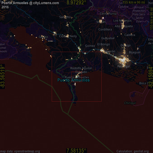
Analysis of Puerto Armuelles night lights 2016
Square area 10x10 km:
 0.62%
0.62%90-99
1.03%80-89
1.03%70-79
1.45%60-69
1.45%50-59
0.62%40-49
1.45%30-39
3.31%20-29
1.24%10-19
1.24%0-9
86.57%Square area 50x50 km:
0.04%90-99
0.16%80-89
0.04%70-79
0.08%60-69
0.24%50-59
0.15%40-49
0.19%30-39
0.28%20-29
0.17%10-19
0.09%0-9
98.57%Clear (daylight) street map image can be seen on geolist.org.
Map coordinates:
8° 58' 22.5" North, 83° 33' 54.7" West
8° 16' 39.9" North, 82° 51' 43.4" West
7° 34' 52.9" North, 82° 9' 32.2" West
Some cities around Puerto Armuelles sort by population:
• David
50.3 km =31.3 mi,  70°
70°
• La Concepción
37.4 km =23.2 mi,  45°
45°
• Pedregal
48 km =29.8 mi,  78°
78°
• Las Lomas
54.9 km =34.1 mi, 72°
• Volcán
60.3 km =37.5 mi,  24°
24°
• Corredor, CR
41.3 km =25.7 mi,  347°
347°
• Golfito, CR
45.5 km =28.3 mi,  322°
322°
• San Pablo Viejo Abajo
44.2 km =27.5 mi,  63°
63°
3702431 (p: 11,743)
Sources (retrieved 2019-11-25):
» Earth at Night: Flat Maps 2012, 2016