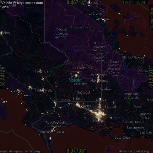
Volcán night lights from space
Night Light of Volcán (Chiriquí) from space (Panama) Src. Average luminocity for 10x10km area is 8.8781% and for 50x50km: 1.3572%.
Analysis of Volcán night lights 2016
Square area 10x10 km:
 0%
0%90-99
2.07%80-89
0%70-79
1.03%60-69
3.72%50-59
2.69%40-49
1.24%30-39
0%20-29
0.83%10-19
0%0-9
88.43%Square area 50x50 km:
0%90-99
0.17%80-89
0.29%70-79
0.14%60-69
0.26%50-59
0.21%40-49
0.13%30-39
0.39%20-29
0.3%10-19
0.1%0-9
98%Clear (daylight) street map image can be seen on geolist.org.
Map coordinates:
9° 28' 1.7" North, 83° 20' 28.9" West
8° 46' 22.5" North, 82° 38' 17.6" West
8° 4' 38.6" North, 81° 56' 6.4" West
Some cities around Volcán sort by population:
• David
44.7 km =27.8 mi,  149°
149°
• La Concepción
29.1 km =18.1 mi,  175°
175°
• Pedregal
50.5 km =31.4 mi, 153°
• Las Lomas
47.1 km =29.3 mi,  144°
144°
• Corredor, CR
36.9 km =22.9 mi,  246°
246°
• Golfito, CR
55.5 km =34.5 mi, 250°
• Boquete
21.6 km =13.4 mi,  87°
87°
• San Pablo Viejo Abajo
38.6 km =24 mi,  157°
157°
3700017 (p: 10,286)
Sources (retrieved 2019-11-25):
» Earth at Night: Flat Maps 2012, 2016