Corredor night lights from space
Night Light of Corredor (Puntarenas) from space (Costa Rica) Src. Average luminocity for 10x10km area is 5.7686% and for 50x50km: 1.8717%.
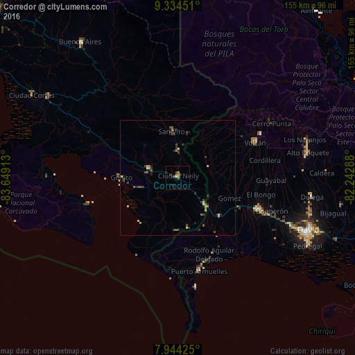
Analysis of Corredor night lights 2016
Square area 10x10 km:
 0%
0%90-99
0%80-89
0.83%70-79
0.83%60-69
1.86%50-59
0.62%40-49
2.07%30-39
0.83%20-29
3.31%10-19
0.83%0-9
88.84%Square area 50x50 km:
0.02%90-99
0.21%80-89
0.24%70-79
0.14%60-69
0.4%50-59
0.23%40-49
0.51%30-39
0.64%20-29
0.61%10-19
0.3%0-9
96.69%Clear (daylight) street map image can be seen on geolist.org.
Map coordinates:
9° 20' 4.2" North, 83° 38' 56.9" West
8° 38' 24.1" North, 82° 56' 45.6" West
7° 56' 39.3" North, 82° 14' 34.4" West
Some cities around Corredor sort by population:
• David, PA
61.4 km =38.2 mi,  112°
112°
• La Concepción, PA
38.7 km =24 mi, 111°
• Pedregal, PA
63.9 km =39.7 mi,  118°
118°
• Puerto Armuelles, PA
41.3 km =25.7 mi,  167°
167°
• Volcán, PA
36.9 km =22.9 mi,  66°
66°
• Golfito
18.9 km =11.7 mi,  257°
257°
• Boquete, PA
57.6 km =35.8 mi, 74°
• San Pablo Viejo Abajo, PA
53.1 km =33 mi, 113°
3624066 (p: 7,084)
Sources (retrieved 2019-11-25):
» Earth at Night: Flat Maps 2012, 2016