Penonomé night lights from space
Night Light of Penonomé (Coclé) from space (Panama) Src. Average luminocity for 10x10km area is 25.8306% and for 50x50km: 3.365%.
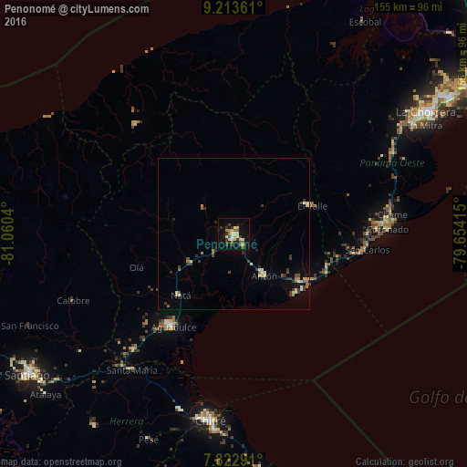
Analysis of Penonomé night lights 2016
Square area 10x10 km:
 0.62%
0.62%90-99
6.4%80-89
4.55%70-79
3.1%60-69
2.69%50-59
3.31%40-49
2.48%30-39
6.4%20-29
2.27%10-19
23.55%0-9
44.63%Square area 50x50 km:
0.12%90-99
0.61%80-89
0.48%70-79
0.31%60-69
0.39%50-59
0.41%40-49
0.41%30-39
0.99%20-29
0.47%10-19
1.62%0-9
94.18%Clear (daylight) street map image can be seen on geolist.org.
Map coordinates:
9° 12' 49" North, 81° 3' 37.4" West
8° 31' 8" North, 80° 21' 26.2" West
7° 49' 22.5" North, 79° 39' 14.9" West
Some cities around Penonomé sort by population:
• Pocrí
35.9 km =22.3 mi,  216°
216°
• San Juan Bautista
62.3 km =38.7 mi,  185°
185°
• Monagrillo
60.4 km =37.5 mi, 188°
• Llano Bonito
60.7 km =37.7 mi, 186°
• Aguadulce
37.2 km =23.1 mi,  213°
213°
• Antón
17.2 km =10.7 mi,  141°
141°
• Río Hato
26.1 km =16.2 mi,  126°
126°
• Natá
27.4 km =17 mi, 220°
3703068 (p: 16,250)
Sources (retrieved 2019-11-25):
» Earth at Night: Flat Maps 2012, 2016