Pocrí night lights from space
Night Light of Pocrí (Coclé) from space (Panama) Src. Average luminocity for 10x10km area is 22.0186% and for 50x50km: 2.754%.
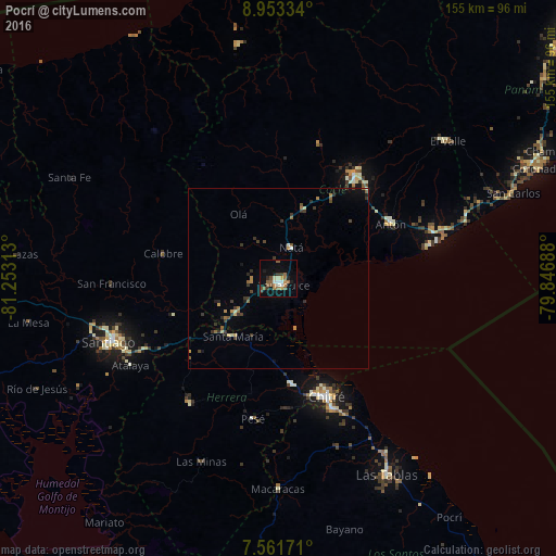
Analysis of Pocrí night lights 2016
Square area 10x10 km:
 1.65%
1.65%90-99
2.89%80-89
2.48%70-79
1.86%60-69
4.96%50-59
5.79%40-49
1.86%30-39
3.51%20-29
1.45%10-19
15.29%0-9
58.26%Square area 50x50 km:
0.08%90-99
0.23%80-89
0.31%70-79
0.31%60-69
0.51%50-59
0.48%40-49
0.35%30-39
0.97%20-29
0.39%10-19
1.02%0-9
95.35%Clear (daylight) street map image can be seen on geolist.org.
Map coordinates:
8° 57' 12" North, 81° 15' 11.3" West
8° 15' 29.3" North, 80° 33' 0" West
7° 33' 42.2" North, 79° 50' 48.8" West
Some cities around Pocrí sort by population:
• Penonomé
35.9 km =22.3 mi,  36°
36°
• Monagrillo
33.1 km =20.6 mi,  158°
158°
• Llano Bonito
34.6 km =21.5 mi,  154°
154°
• Chitré
35.6 km =22.1 mi, 158°
• Aguadulce
1.9 km =1.2 mi,  166°
166°
• La Arena
33.6 km =20.9 mi, 163°
• Antón
35.4 km =22 mi,  64°
64°
• Natá
8.9 km =5.5 mi,  22°
22°
3702631 (p: 12,304)
Sources (retrieved 2019-11-25):
» Earth at Night: Flat Maps 2012, 2016