Monagrillo night lights from space
Night Light of Monagrillo (Herrera) from space (Panama) Src. Average luminocity for 10x10km area is 32.9711% and for 50x50km: 3.9582%.
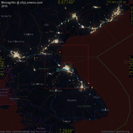
Analysis of Monagrillo night lights 2016
Square area 10x10 km:
 4.34%
4.34%90-99
8.68%80-89
3.93%70-79
2.89%60-69
4.75%50-59
4.55%40-49
0.62%30-39
4.13%20-29
6.61%10-19
32.64%0-9
26.86%Square area 50x50 km:
0.22%90-99
0.75%80-89
0.44%70-79
0.29%60-69
0.51%50-59
0.51%40-49
0.42%30-39
1.14%20-29
0.64%10-19
3.2%0-9
91.9%Clear (daylight) street map image can be seen on geolist.org.
Map coordinates:
8° 40' 39" North, 81° 8' 26.8" West
7° 58' 54.4" North, 80° 26' 15.5" West
7° 17' 5.6" North, 79° 44' 4.3" West
Some cities around Monagrillo sort by population:
• Pocrí
33.1 km =20.6 mi,  338°
338°
• San Juan Bautista
3.6 km =2.2 mi,  130°
130°
• Llano Bonito
2.4 km =1.5 mi,  104°
104°
• Chitré
2.5 km =1.6 mi,  158°
158°
• Las Tablas
30.1 km =18.7 mi,  143°
143°
• Aguadulce
31.3 km =19.4 mi, 337°
• La Arena
3.4 km =2.1 mi,  242°
242°
• Los Santos
5.9 km =3.7 mi, 156°
3704187 (p: 10,821)
Sources (retrieved 2019-11-25):
» Earth at Night: Flat Maps 2012, 2016