La Cabima night lights from space
Night Light of La Cabima (Panamá) from space (Panama) Src. Average luminocity for 10x10km area is 54.987% and for 50x50km: 24.5627%.
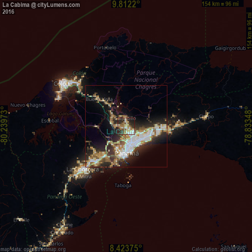
Analysis of La Cabima night lights 2016
Square area 10x10 km:
 4.98%
4.98%90-99
11.9%80-89
12.12%70-79
3.46%60-69
13.2%50-59
9.74%40-49
3.68%30-39
10.39%20-29
22.51%10-19
7.79%0-9
0.22%Square area 50x50 km:
4.7%90-99
4.58%80-89
3.04%70-79
2.68%60-69
3.21%50-59
3.83%40-49
2.61%30-39
4.22%20-29
7.56%10-19
10.06%0-9
53.51%Clear (daylight) street map image can be seen on geolist.org.
Map coordinates:
9° 48' 43.9" North, 80° 14' 23" West
9° 7' 7.1" North, 79° 32' 11.8" West
8° 25' 25.5" North, 78° 50' 0.5" West
Some cities around La Cabima sort by population:
• San Miguelito
10.5 km =6.5 mi,  136°
136°
• Juan Díaz
12.2 km =7.6 mi,  128°
128°
• Las Cumbres
3.4 km =2.1 mi,  164°
164°
• Chilibre
9.9 km =6.2 mi,  291°
291°
• Río Abajo
12 km =7.5 mi, 160°
• Alcalde Díaz
2.2 km =1.4 mi,  274°
274°
• San Vicente
6.7 km =4.2 mi, 266°
• Gonzalillo
3.5 km =2.2 mi,  147°
147°
3708066 (p: 17,975)
Sources (retrieved 2019-11-25):
» Earth at Night: Flat Maps 2012, 2016