Gonzalillo night lights from space
Night Light of Gonzalillo (Panamá) from space (Panama) Src. Average luminocity for 10x10km area is 68.3745% and for 50x50km: 24.9935%.
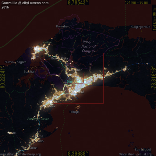
Analysis of Gonzalillo night lights 2016
Square area 10x10 km:
 12.55%
90-99
16.02%80-89
13.85%70-79
7.79%60-69
12.77%50-59
12.99%40-49
4.33%30-39
8.87%20-29
9.09%10-19
1.73%0-9
0%Square area 50x50 km:
4.72%90-99
4.54%80-89
3.08%70-79
2.79%60-69
3.35%50-59
3.82%40-49
2.73%30-39
4.27%20-29
7.78%10-19
11.07%0-9
51.85%Clear (daylight) street map image can be seen on geolist.org.
Map coordinates:
9° 47' 7.5" North, 80° 13' 20.7" West
9° 5' 30.6" North, 79° 31' 9.4" West
8° 23' 48.8" North, 78° 48' 58.2" West
Some cities around Gonzalillo sort by population:
• San Miguelito
7.1 km =4.4 mi,  130°
130°
• Juan Díaz
8.9 km =5.5 mi,  121°
121°
• Las Cumbres
1 km =0.6 mi,  252°
252°
• Parque Lefevre
9.2 km =5.7 mi,  154°
154°
• Río Abajo
8.6 km =5.3 mi,  165°
165°
• Alcalde Díaz
5.2 km =3.2 mi,  307°
307°
• La Cabima
3.5 km =2.2 mi,  327°
327°
• San Vicente
9 km =5.6 mi,  286°
286°
10180075 (p: 7,793)
Sources (retrieved 2019-11-25):
» Earth at Night: Flat Maps 2012, 2016