Ilām night lights from space
Night Light of Ilām (Province 1) from space (Nepal) Src. Average luminocity for 10x10km area is 0.9504% and for 50x50km: 0.1822%.
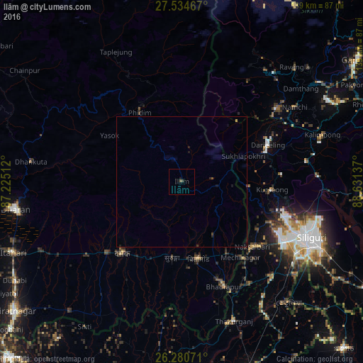
Analysis of Ilām night lights 2016
Square area 10x10 km:
 0%
0%90-99
0%80-89
0%70-79
0%60-69
0%50-59
0.79%40-49
0.6%30-39
0.2%20-29
0.2%10-19
0.6%0-9
97.62%Square area 50x50 km:
0%90-99
0%80-89
0%70-79
0.03%60-69
0%50-59
0.07%40-49
0.06%30-39
0.02%20-29
0.13%10-19
0.11%0-9
99.57%Clear (daylight) street map image can be seen on geolist.org.
Map coordinates:
27° 32' 4.8" North, 87° 13' 30.4" East
26° 54' 33.9" North, 87° 55' 41.7" East
26° 16' 50.6" North, 88° 37' 52.9" East
Some cities around Ilām sort by population:
• Siliguri, IN
54.4 km =33.8 mi,  114°
114°
• Dārjiling, IN
36.3 km =22.6 mi,  67°
67°
• Naksalbāri, IN
38.4 km =23.9 mi,  131°
131°
• Kārsiyāng, IN
34.7 km =21.6 mi,  94°
94°
• Kālimpong, IN
57.1 km =35.5 mi, 71°
• Bhadrapur
43.8 km =27.2 mi,  157°
157°
• Bagdogra, IN
44.7 km =27.8 mi,  121°
121°
• Mirik, IN
26.1 km =16.2 mi,  95°
95°
1283333 (p: 17,491)
Sources (retrieved 2019-11-25):
» Earth at Night: Flat Maps 2012, 2016