Bagdogra night lights from space
Night Light of Bagdogra (West Bengal) from space (India) Src. Average luminocity for 10x10km area is 57.572% and for 50x50km: 17.3632%.
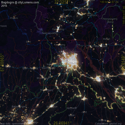
Analysis of Bagdogra night lights 2016
Square area 10x10 km:
 16.29%
90-99
16.29%80-89
3.03%70-79
7.2%60-69
5.11%50-59
5.49%40-49
7.39%30-39
2.46%20-29
17.8%10-19
16.86%0-9
2.08%Square area 50x50 km:
3.76%90-99
3.2%80-89
1.44%70-79
1.6%60-69
1.74%50-59
2.35%40-49
2.6%30-39
2.94%20-29
4.87%10-19
7.33%0-9
68.17%Clear (daylight) street map image can be seen on geolist.org.
Map coordinates:
27° 19' 32.5" North, 87° 36' 31.1" East
26° 41' 57.4" North, 88° 18' 42.4" East
26° 4' 9.9" North, 89° 0' 53.6" East
Some cities around Bagdogra sort by population:
• Siliguri
11.7 km =7.3 mi,  84°
84°
• Dārjiling
37.4 km =23.2 mi,  353°
353°
• Naksalbāri
9.3 km =5.8 mi,  258°
258°
• Kārsiyāng
20.7 km =12.9 mi, 350°
• Bhadrapur, NP
27.7 km =17.2 mi,  231°
231°
• Thākurganj
35.2 km =21.9 mi,  210°
210°
• Odlābāri
35 km =21.7 mi,  64°
64°
• Mirik
24.2 km =15 mi,  330°
330°
1277897 (p: 17,372)
Sources (retrieved 2019-11-25):
» Earth at Night: Flat Maps 2012, 2016