Raufoss night lights from space
Night Light of Raufoss (Oppland) from space (Norway) Src. Average luminocity for 10x10km area is 13.3896% and for 50x50km: 4.1306%.
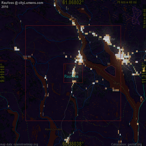
Analysis of Raufoss night lights 2016
Square area 10x10 km:
 1.41%
1.41%90-99
1.62%80-89
1.19%70-79
2.27%60-69
2.27%50-59
1.41%40-49
0.65%30-39
0%20-29
0.65%10-19
22.73%0-9
65.8%Square area 50x50 km:
0.67%90-99
0.81%80-89
0.36%70-79
0.39%60-69
0.39%50-59
0.4%40-49
0.4%30-39
0.24%20-29
0.72%10-19
4.13%0-9
91.5%Clear (daylight) street map image can be seen on geolist.org.
Map coordinates:
61° 4' 4.9" North, 9° 54' 36.6" East
60° 43' 33.7" North, 10° 36' 47.9" East
60° 22' 49.4" North, 11° 18' 59.1" East
Some cities around Raufoss sort by population:
• Hamar
25.8 km =16 mi,  72°
72°
• Lillehammer
44 km =27.3 mi,  349°
349°
• Gjøvik
8.8 km =5.5 mi,  28°
28°
• Hønefoss
65.1 km =40.5 mi,  197°
197°
• Elverum
54.3 km =33.7 mi, 71°
• Jessheim
71.9 km =44.7 mi,  154°
154°
• Råholt
58.9 km =36.6 mi, 148°
• Brumunddal
24.7 km =15.3 mi,  45°
45°
3142228 (p: 6,052)
Sources (retrieved 2019-11-25):
» Earth at Night: Flat Maps 2012, 2016