Raamsdonksveer night lights from space
Night Light of Raamsdonksveer (North Brabant) from space (Netherlands) Src. Average luminocity for 10x10km area is 38.5028% and for 50x50km: 29.5986%.
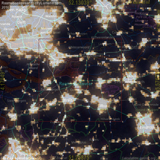
Analysis of Raamsdonksveer night lights 2016
Square area 10x10 km:
 7.28%
7.28%90-99
6.58%80-89
4.2%70-79
4.76%60-69
3.92%50-59
4.76%40-49
2.8%30-39
7.84%20-29
15.13%10-19
30.25%0-9
12.46%Square area 50x50 km:
5.84%90-99
6.19%80-89
2.61%70-79
2.52%60-69
2.55%50-59
2.66%40-49
3.03%30-39
4.54%20-29
10.24%10-19
27.19%0-9
32.61%Clear (daylight) street map image can be seen on geolist.org.
Map coordinates:
52° 7' 49.4" North, 4° 10' 13.8" East
51° 41' 48" North, 4° 52' 25" East
51° 15' 31.5" North, 5° 34' 36.3" East
Some cities around Raamsdonksveer sort by population:
• Oosterhout
5.8 km =3.6 mi,  189°
189°
• Dongen
9 km =5.6 mi,  149°
149°
• Geertruidenberg
1.3 km =0.8 mi,  295°
295°
• Hoge Vucht
11.4 km =7.1 mi,  209°
209°
• Made
6 km =3.7 mi,  248°
248°
• Teteringen
10.4 km =6.5 mi,  200°
200°
• Terheijden
10.1 km =6.3 mi,  234°
234°
• Waspik
5 km =3.1 mi,  102°
102°
2748361 (p: 6,590)
Sources (retrieved 2019-11-25):
» Earth at Night: Flat Maps 2012, 2016