Vleuten night lights from space
Night Light of Vleuten (Utrecht) from space (Netherlands) Src. Average luminocity for 10x10km area is 59.0066% and for 50x50km: 32.7515%.
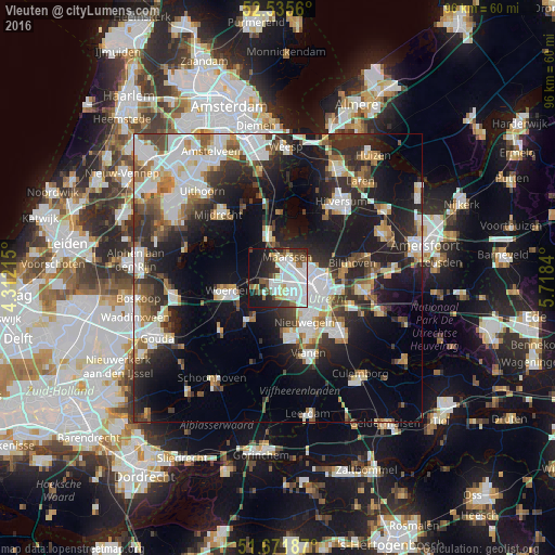
Analysis of Vleuten night lights 2016
Square area 10x10 km:
 22.88%
90-99
14.81%80-89
4.1%70-79
2.91%60-69
3.97%50-59
6.35%40-49
5.95%30-39
4.5%20-29
12.7%10-19
17.86%0-9
3.97%Square area 50x50 km:
7.42%90-99
7.06%80-89
2.77%70-79
2.97%60-69
3.48%50-59
3.25%40-49
4.18%30-39
4.59%20-29
10.52%10-19
18.06%0-9
35.71%Clear (daylight) street map image can be seen on geolist.org.
Map coordinates:
52° 32' 8.2" North, 4° 18' 43.7" East
52° 6' 21" North, 5° 0' 55" East
51° 40' 18.7" North, 5° 43' 6.2" East
Some cities around Vleuten sort by population:
• Utrecht
7.5 km =4.7 mi,  102°
102°
• Nieuwegein
9.6 km =6 mi,  152°
152°
• Woerden
9.3 km =5.8 mi,  255°
255°
• Maarssen
4.1 km =2.5 mi,  25°
25°
• Breukelen
7.7 km =4.8 mi,  352°
352°
• Lunetten
9.5 km =5.9 mi,  120°
120°
• Veldhuizen
3.4 km =2.1 mi,  183°
183°
• Montfoort
7.9 km =4.9 mi,  212°
212°
2745431 (p: 6,945)
Sources (retrieved 2019-11-25):
» Earth at Night: Flat Maps 2012, 2016