Leerdam night lights from space
Night Light of Leerdam (Utrecht) from space (Netherlands) Src. Average luminocity for 10x10km area is 8.0669% and for 50x50km: 23.7155%.

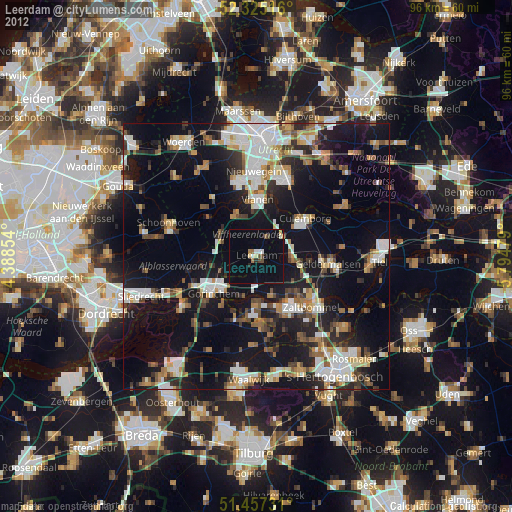
Analysis of Leerdam night lights 2016
Square area 10x10 km:
 0.63%
0.63%90-99
1.77%80-89
0.13%70-79
0%60-69
0.63%50-59
1.39%40-49
1.01%30-39
0%20-29
0.51%10-19
0.38%0-9
93.56%Square area 50x50 km:
4.7%90-99
4.45%80-89
2.1%70-79
2.05%60-69
2.21%50-59
2.43%40-49
2.74%30-39
3.3%20-29
5.91%10-19
21.48%0-9
48.62%Clear (daylight) street map image can be seen on geolist.org.
Map coordinates:
52° 19' 30.6" North, 4° 23' 18.7" East
51° 53' 36" North, 5° 5' 30" East
51° 27' 26.3" North, 5° 47' 41.2" East
Some cities around Leerdam sort by population:
• Gorinchem
10.3 km =6.4 mi,  232°
232°
• IJsselstein
14.5 km =9 mi,  346°
346°
• Culemborg
11.6 km =7.2 mi,  53°
53°
• Zaltbommel
14 km =8.7 mi,  131°
131°
• Geldermalsen
13.6 km =8.5 mi,  95°
95°
• Vianen
11 km =6.8 mi,  0°
0°
• Woudrichem
10.7 km =6.6 mi,  215°
215°
• Lopik
13.2 km =8.2 mi,  311°
311°
2751808 (p: 20,758)
Sources (retrieved 2019-11-25):
» Earth at Night: Flat Maps 2012, 2016